Geoscience Reference
In-Depth Information
the steep wave-cut cliffs in the area of Cape Taran, where the lines were moved
upwards from the overlying wave-cut platform edges. Thus, the fossil coast levels
as presented in this work are located between the levels defined by the wave-cut
We identified nine axial lines of wave-cut cliffs with average depths of 21, 29,
not charted. The resolution of our method is too low to be applied to the high-energy
coastal zone, where the relic topography is masked by modern lithodynamics. The
highest (coastal) level (3-0 m) was therefore beyond the area of study.
Due to the scarcity of initial bathymetric data in certain areas of the bottom, not
all coast levels could be laid out. Insufficient spatial resolution forced us to merge
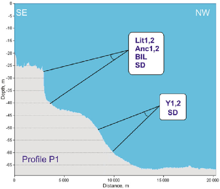
the coastlines which are then indicated as polygenic. An example of the polygenic
and the adjacent wave-cut platform constituting a seafloor segment between 3,000
and 7,000 m on the horizontal scale. The structures were initially tectonic in ori-
gin, with their subsequent evolution being affected by wave-driven erosion during
Fig. 10.4
An example of polygenic cliffs north-west of Sambian Peninsula (echo-sounder profile
1inFig.
10.3
)
. Insets indicate abbreviations of the Baltic evolution stages; SD, structure-dependent
cliffs