Geoscience Reference
In-Depth Information
ocean level. Ramsay ( 1917 ) found similar results from the Salpauselkkä area in
Finland, showing that the BIL had the highest shoreline. However, Ramsay ( 1928 ,
1929 ) later studied shorelines in Estonia and Ingermanland (NW Russia) and found
that uppermost shores there are older than BIL shores in Finland and proposed
that they represent the shores of the local ice lakes. Since then, late-glacial shore-
lines in Estonia and NW Russia were divided between local ice lakes and BIL
(Markov 1931 , Pärna 1960 , Kessel and Raukas 1979 ) . It was assumed that the local
ice lake shorelines developed during Alleröd and BIL shorelines during Younger
Dryas. In contrast, in Latvia BIL started to develop in Alleröd (Grinbergs 1957 ,
Veinbergs 1979 ) , at the same time when in Estonia and NW Russia local ice lakes
existed.
Estonian local ice lakes were studied in detail by Pärna ( 1960 ) , who found that
the largest proglacial lakes developed during the Pandivere/Neva stage (13,300
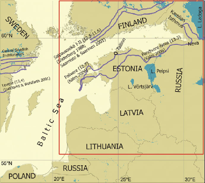
corrected varve years BP; Saarnisto and Saarinen 2001 , Hang 2003 , Kalm 2006 ;
Fig. 9.1 Overview map of the study area. Blue lines indicate ice-marginal positions, discussed in
the text, with ages (cal. kyears BP) according to Kalm ( 2006 ) , Lundqvist and Wohlfarth ( 2001 )
and Saarnisto and Saarinen ( 2001 ) . Red box indicates the area shown in Figs. 9.2 , 9.3 , 9.4 , 9.5
and 9.6
 
Search WWH ::


Custom Search