Geoscience Reference
In-Depth Information
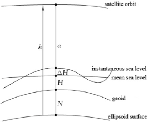
Fig. 2.17 Geometric
relationship in satellite
altimetry
The Observed Quantity in Altimetry and Error Analysis
Equation (2.23) is a simplified observation equation of the altimeter, which needs to
be refined in practical application. The geometric relationship in SA shown in
Fig.
2.17
yields:
h
¼
N
þ
H
þ ʔ
H
þ
a
þ
d,
ð
2
:
24
Þ
where h is the ellipsoidal height of the altimeter satellite based on orbit computa-
tions, is the geoid height, H is the sea surface topography,
ʔ
H is caused by the
instantaneous
tid
al effect, and a is the altimeter measurement.
H
H in (2.23). The quantity a is observed by the altimeter and requires
atmospheric correction, which should be referred to the satellite's center of mass.
The difference between the geoid and the mean sea level is called the sea surface
topography, which can reach 1-2 m. The mean sea level is defined as a stationary
sea surface not changing with time. The difference between the sea surface and the
geoid is caused by differences in seawater salinity and temperature, a wide range of
pressure differences, strong tidal currents, etc. For a resolution of better than 2 m, it
is no longer valid to use mean sea level as a close approximation to the geoid.
Besides, there are difficulties in connecting up the height systems obtained by a
variety of tidal observational stations.
Errors and corrections of altimetric observations are categorized into three types;
namely, the difference between the actual and the calculated orbit (the orbital
error), the effects on signal propagation path, and the difference between the
instantaneous sea surface and the geoid.
The orbital error mainly results from the accuracy of the Earth gravity model
used in orbit calculation, errors in the tracking stations' coordinates, errors or
limitations in the tracking systems, and errors in the model used for orbit
þ ʔ
H
¼
Search WWH ::

Custom Search