Geoscience Reference
In-Depth Information
65°
70°
75°
80°
85°
90°
95°
100°
105°
110°
115°
120°
125°
130°
135°
140°
145°
45°
45°
40°
40°
35°
35°
30°
30°
25°
110°
115°
120°
20°
20°
20°
15°
15°
10°
10°
5°
15°
5°
90°
95°
100°
105°
110°
115°
120°
125°
110°
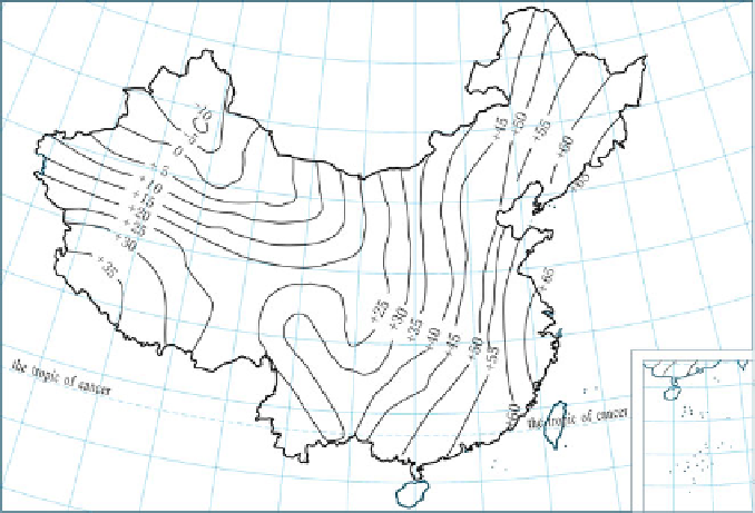
Fig. 7.8 China's mainland geoid, Beijing Coordinate System 1954
discussion and study to the issue of establishing a new geodetic coordinate system
in China, holding that BJS54 had some technical shortcomings. Establishing
China's own brand-new geodetic coordinate system was imperative and timely.
In the conference summary, the following principles were defined concerning the
issue of establishing China's geodetic coordinate system:
1. The integrated adjustments of the national astro-geodetic network will be carried
out on a new surface of a reference ellipsoid. Thus, a new geodetic coordinate
system should first be established, which was named the National Geodetic
Coordinate System 1980 (later in practical use it is always referred to as the
Xi'an Coordinate System 1980, abbreviated as XAS80).
2. The geodetic origin of the coordinate system is located at the center of China,
close to Xi'an. The exact place is in Yongle township, Jingyang county, Shaanxi
province.
3. The Earth ellipsoid parameters recommended by the IUGG in 1975 integrated
the latest data throughout the world. The XAS80 has adopted four basic param-
eters (a, J
2
, GM, and
), and has calculated the Earth's flattening, normal gravity
value at the equator, and coefficients of the normal gravity formula based on the
four parameters.
4. The minor axis of the ellipsoid XAS80 is defined parallel to the direction from
the Earth's center of mass to the polar origin JYD
1968.0
, and the initial geodetic
ˉ
Search WWH ::

Custom Search