Geoscience Reference
In-Depth Information
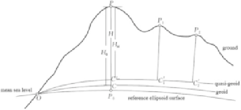
Fig. 4.12 Reference
ellipsoid, geoid, and quasi-
geoid
H
¼
H
N
þ ʶ
,
ð
4
:
42
Þ
where H
N
is the normal height and
is the distance from the quasi-geoid to the
reference ellipsoid, called the height anomaly.
Figure
4.12
illustrates the relationship between the reference ellipsoid, the geoid,
and the quasi-geoid and their corresponding geodetic height, orthometric height,
and normal height.
ʶ
4.4.2 Determination of Height Anomaly or Geoid Height
As pointed out previously, the geodetic height of a surface point consists of the
normal height and the height anomaly. Given the geodetic height and the normal
height of a point, the height anomaly can be computed from the difference between
the two, namely:
ʶ ¼
H
H
N
:
ð
4
:
43
Þ
Using GPS measurements, the geodetic longitude L and latitude B and the
geodetic height H of a surface point can be determined precisely. If leveling is
also carried out on the GPS point (this point is called the GPS-leveling point), then
the normal height H
N
of this point can be calculated and the height anomaly of this
point can be determined by (
4.43
).
By setting a few GPS-leveling points in a certain region, several discrete
values
of this region can be determined, and thus the quasi-geoid of this region can be fitted
through a mathematical method (i.e., deducing the height anomaly of an unknown
point). Such a method for deducing the height anomaly is called the GPS leveling
method. A variety of mathematical methods are used in GPS leveling, such as the
polynomial fitting method, polyhedral function fitting, the moving surface method,
the weighted average method, the collocation method, etc. In real applications, GPS
leveling and gravity data are usually used for a combined solution. Here, we will
only present the basics of GPS leveling rather than provide a thorough review of the
ʶ
Search WWH ::

Custom Search