Geoscience Reference
In-Depth Information
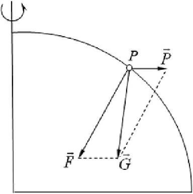
Fig. 4.6 Direction of the
plumb line
space, so points at different heights will result in different level surfaces. The level
surface is a physical reality because it is a surface of constant geopotential, i.e., no
work is done in moving a mass along a frictionless level surface. The level surface
is also known as the equipotential surface of gravity. The vertical at each point on
the level surface is orthogonal to the plane.
When angles are measured using theodolites, or height differences are deter-
mined using leveling instruments, the instruments should all be leveled. While
observing the horizontal angle, the bubble in the spirit level of the theodolite should
rest in the middle. Thus, by centering the bubble, the line of sight is made
horizontal. The vertical axis of the instrument coincides with the direction of the
plumb line. The horizontal plane measured by the horizontal circle is a plane
tangent to the level surface. Therefore, the horizontal angles actually observed
are the angles on level surfaces at different heights. Likewise, the height difference
determined using leveling methods is the distance along the plumb line between
level surfaces. The astronomical longitude and latitude as well as astronomical
azimuth also refer to the level surface and plumb line. Thus, the level surface and
plumb line are the reference surface and the datum line for field operations using
theodolites, leveling instruments, and such optical measuring instruments.
There are many equipotential surfaces. We define one of them as the geoid.
The geoid is the equipotential surface, which approximately coincides with the
mean sea level (MSL) in the ocean and its extension under the continents. Oceans
cover about 71 % of the Earth's surface, and the average elevation of continents is
about 800 m above MSL, about one eight-thousandth of the Earth's radius, which
means that the geoidal body closely approximates the natural surface of the Earth.
As a result, it is natural to employ the geoid as a representation of the Earth. The
geoid also serves as a reference surface for height determination of a given point on
the Earth's surface while studying the shape of the Earth's surface. Meanwhile, the
geoid is also employed as the reference surface for reduction of the astronomical
longitude, latitude, azimuth, and the values of gravity.
Search WWH ::

Custom Search