Geoscience Reference
In-Depth Information
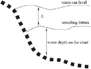
Fig. 3.15 The sounding or
chart datum
MSL connected to the unified national height system. The location of the chart
datum is typically selected at a vertical distance L below the local multiyear MSL
(Fig.
3.15
). The sounding datum should be determined by taking both the naviga-
tional safety and the rate of waterway utilization into account. Hence, it should be
situated below the MSL and is approximately the tidal surface of the lowest water
level. Countries worldwide have applied different formulae to calculate L based on
the tidal regimes of the various waters, and there are hence a variety of chart datum
choices, such as the theoretical lowest tide (TLT), lowest astronomical tide (LAT),
mean lower low water (MLLW), lowest low water (LLW), mean lower low water
springs (MLLWS), Indian spring low water (ISLW), mean low water (MLW), mean
low water springs (MLWS), equatorial springs low water (ESLW), etc.
The tidal data of major ports are indicated on the chart, so it is possible to
calculate the depth of water at a given point and a given time by adding the charted
depth to the height of the tide at a particular moment found in the tide tables. When
the chart datum is not compatible with the tidal datum, corrections also need to be
applied.
The Sounding Datum Adopted by China
Prior to 1956, China adopted the lower low water as the chart datum. After 1956,
the theoretically lowest tide level determined by Vladimirsky (abbreviated as the
theoretical lowest tide) was taken as the chart datum.
3.2.3 Plans for Establishing China's National Vertical
Control Network and Its Precision
The principles of establishing the national horizontal and vertical control networks
are analogous. Vertical control networks are established based on four orders from
higher to lower and from global to local, following the methods of stepwise control
and densification. The leveling lines of different orders are generally required to be
Search WWH ::

Custom Search