Geoscience Reference
In-Depth Information
65°
70°
75°
80°
85°
90°
95°
100°
105°
110°
115°
120°
125°
130°
135°
140°
145°
45°
45°
40°
40°
35°
35°
30°
30°
25°
110°
115°
120°
20°
20°
20°
15°
15°
10°
10°
5°
15°
5°
90°
95°
100°
105°
110°
115°
120°
125°
110°
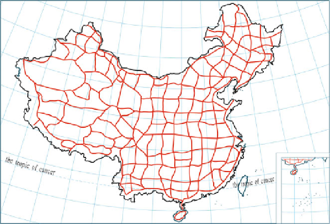
Fig. 3.10 China astro-geodetic network: curves indicate the first-order triangulation chain; blank
areas in the curved quadrangles indicate the second-order triangulation network
measurement, angular measurement, adjustment computations, etc. (see SBSM
2004). Our discussions will focus on the first four aspects.
Requirements for the Position of Control Points
The position of horizontal control points should satisfy the following requirements
for either technical design or reconnaissance for control point selection:
1. The side lengths, angles, and graphical structures formed between control points
should completely conform to the requirements in the corresponding technical
standards.
2. The control points should be marked where the sites can be extended easily and
lower-order points are conveniently densified.
3. The position should be selected where the survey mark can be well preserved
over time and it will be safe and convenient to erect the monument and to
observe it. Therefore, the position should be selected in high land with solid soil
and a fine drainage system, and should be a suitable distance away from
highways, railways, high-voltage wires, and other buildings.
4. The line of sight should avoid slopes or coastlines of lakes and rivers to ensure a
clear and stable image of the observation target and to reduce the effects of
horizontal refraction in order to improve the accuracy of observation. The line of
Search WWH ::

Custom Search