Geoscience Reference
In-Depth Information
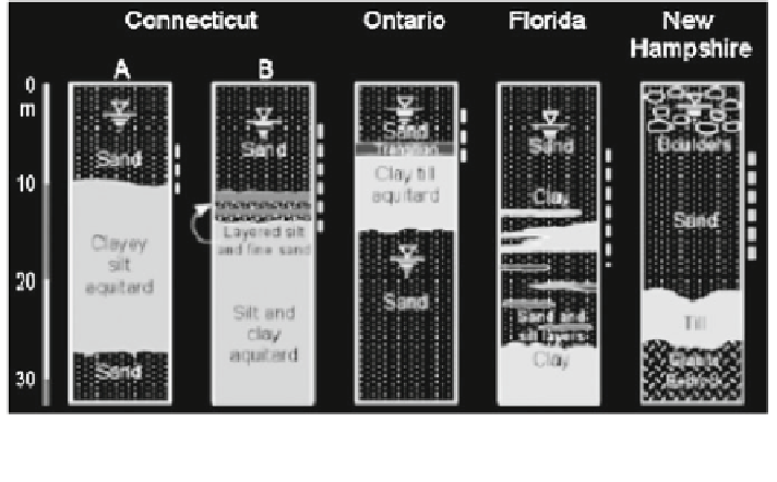
Fig. 12.49 Columns representing the geology of five study sites. The depth zone of DNAPL
contamination investigated at each site is indicated by the dashed lines (Parker et al.
2003
)
NAPL source ages, its geometry changes, and the amount of soluble NAPL
fraction in water may decrease.
Contamination of sandy aquifers by DNAPL chlorinated solvents was inves-
tigated at five field study sites in Canada and the United States (Parker et al.
2003
).
Figure
12.49
shows the general geological setting of the studied sites. In all the
sites, the sand deposits forming the aquifer extend up to the ground surface, so that
DNAPLs disposed on the surface infiltrate only a few meters to reach the water
table. Contamination of the study sites started in the 1950s and 1960s, from the
discharge of individual DNAPLs (TCE or PCE) used as routine solvents in metal
industries. Because the DNAPLs entered the subsurface at these sites decades ago,
the DNAPL zones aged due to groundwater dissolution.
It was assumed that initially most DNAPL was found in the coarser grained
zones and more rapid groundwater flow in these zones caused preferential removal
of DNAPL. Groundwater flow is horizontal through the DNAPL source zone,
which creates the down-gradient contaminant plume. Illustration of the evolution
of a layered DNAPL source zone, showing complete dissolution of the residual
trails, is given in Fig.
12.50
. The major finding of the analysis is that DNAPL
originally located in coarser grained layers was removed by groundwater disso-
lution. The present-day DNAPL in the source zone resides only in isolated, thin
horizontal layers and represents only the less soluble or leachable remnants of the
original contaminant zone. DNAPL located in the less permeable layers or in
layered transition zones at the bottom of the aquifer is subject to a slower disso-
lution rate.