Geoscience Reference
In-Depth Information
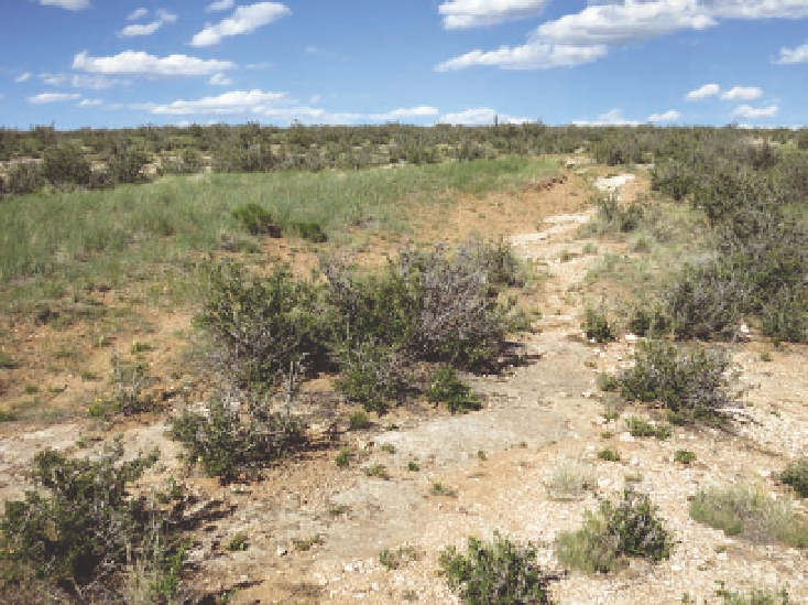
Fig. 17.17. exposed limestone of the Forelle Formation on the
east edge of Laramie now supports a shrubland of mountain-
mahogany. Most likely, parts of this area were mixed-grass
prairie prior to the arrival of the Union Pacific Railroad in
1868, when large numbers of cattle and sheep congregated
in the area because of close proximity to the city springs and
a spur of the railroad, where the animals were loaded onto
stock cars. erosion over most the area would have been an
ongoing process because of the slope of the underlying bed-
rock, but it probably was accelerated by heavy grazing. Flash
floods are known to occur in the area, which would have
contributed further to soil loss. A remnant of the prairie can
be seen in the central part of the photo, where the soil has
not yet eroded. Limestone was quarried in this area, first for
building construction and later for the manufacture of plaster
and cement.
droughts. the way current laws are written, water rights
for wildlife benefits have low priority.
28
Another kind of change is associated with rural sub-
divisions, especially around Laramie, along rivers, and
in the foothills and mountains. As people move to the
country, former grazing land is converted to residen-
tial use, wildlife habitat is fragmented, open space is
diminished, and the potential for problems with inva-
sive plants increases (see chapter 18). Moreover, the
potential pollution of the casper aquifer by a few land-
owners on the outskirts of Laramie is a concern for the
entire community. Guidelines have been proposed that
would protect the aquifer, but this necessarily involves
the cooperation of landowners who have other visions
for their land. currently, rural subdivisions occupy
only about 8 percent of the basin floor, but much of
that is concentrated in the foothills, and the land area
involved increases annually as more people seek alter-
natives to living in town. Accentuating such trends is
the potential for more wind farms, transmission lines,
and roads (see chapter 18).
As in ecosystems throughout the region, invasive
shrublands of the Laramie Basin are still relatively
free of invasive plants, though cheatgrass is becoming
more common in the foothills. the riparian zones are
another matter, where canada thistle, Dalmatian toad-
flax, perennial pepperweed, white top, and spotted and
Russian knapweed are common. Some of their effects
are discussed in previous chapters. native meadow
grasses that originally were harvested for hay included
meadow brome, redtop, and tufted hairgrass, but with
irrigation they have been largely displaced by intro-
duced species, such as foxtail, redtop, smooth brome,
foxtail, was introduced unintentionally when hay bales
were brought to the basin from elsewhere. initially,
some ranchers appreciated its forage value, but now it
Search WWH ::

Custom Search