Geoscience Reference
In-Depth Information
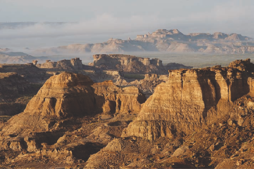
Fig. 9.7. Skull Rim in a desert
wildland known as Adobe
town, part of the Washakie
Basin southeast of Rock
Springs and southwest of
Rawlins. the badlands in this
area are carved from clay-
stones and sandstones of the
Washakie Formation (eocene).
Photo by Ken Driese.
ern Wyoming and southeast Montana, seven types of
shrublands and woodlands have been identified, based
on their dominant plants: shadscale-big sagebrush,
big sagebrush-shadscale-western wheatgrass, big sage-
brush-western wheatgrass, greasewood, skunkbush
sumac-western wheatgrass, Rocky Mountain juniper-
western wheatgrass, and ponderosa pine-juniper. in
addition, on mesa tops capped by erosion-resistant
scoria, there are small patches of mixed-grass prairie.
Greasewood is found near seeps on some slopes. Plant
cover is sometimes contoured in narrow bands that par-
allel beds of gray clay, buff-colored silt, and lignite—an
Ponderosa and limber pine are found in badlands,
along with Utah and Rocky Mountain juniper, but only
on escarpments that are comparatively resistant to ero-
sion. elsewhere erosion occurs before mature trees
have time to develop. Landslides can cause significant
changes.
surrounded by mudflats or playas with only a few plants
(fig. 9.8). the cones seem to provide better conditions
for plant growth than the flats do. At one time, a slurry
the geologist and explorer Ferdinand Hayden was
the first scientist to discover these unusual landforms
when he visited the area in 1877. According to his
report, the mounds at that time had pools of muddy
water at the top. observing that a bubble of gas periodi-
cally rose to the surface of the pools, he and his men
conducted an experiment:
A rifle-ball shot down vertically into one of the
openings produced a sudden eruption of the whole
mass. Water and mud were thrown to a height of
about 10 feet, covering the luckless experimenter
from head to foot. From a safer distance the trial was
several times repeated and almost always followed
by the same result. . . . crude as this test may be, it
shows the presence of gas at some depth, held there
under mechanical pressure.
20
Mud Springs
today, the mud springs appear to be dormant. A
possible cause is the pumping of groundwater from the
Great Divide Basin for livestock and industry, which
could be relieving some of the water pressure that
was important for the creation of these springs. How-
one of the most unusual features of the Great Divide
Basin is the small area of mud springs found just east of
circle Bar Lake (one of the chain Lakes north of Wam-
sutter). these conical mounds are 3-15 feet high and are
Search WWH ::

Custom Search