Geoscience Reference
In-Depth Information
the National Meteorological Information Center of China (1958-2001), and
based on the EASM's gridded index and the definition of EASM's front,
15
we analyzed the climatological characters of EASM's movement and the
relationship between the EASM's movement and the spatial distribution
pattern of the summer rainfall over eastern China in interdecadal time-
scales.
2. The EASM's Movement and Rain Belt in Eastern China
Based on the previous studies, Lu
et al.
15
proposed the definition of EASM's
gridded index by using low-level SW wind and specific humidity, i.e.
Im =
V
sw
−
V
sw
δ
sw
+
Q
−
Q
δq
,
(1)
where
V
sw
is the projection of total wind speed on the SW direction at
a 850 hPa for a grid point,
Q
is the mean specific humidity at 925 and
850 hPa for a grid point;
V
sw
is the projection of 850-hPa total wind
speed on the SW direction, averaged over (10
◦
N-50
◦
N, 90
◦
E-150
◦
E);
Q
is
the mean specific humidity at 925 and 850 hPa over the same area;
δ
sw
and
in the above region.
In the process of the EASM's movement, the Im = 1.0 (= 0.3) line south
(north) of 35
◦
N is denoted as its leading edge. It is proved that the defined
EASM's leading edge (or front) can describe the movement of the EASM
objectively.
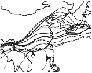
Using the above definition, we get the 44-year average process of the
EASM's movement (1958-2001) (Fig. 1). Based on the advance and retreat
δq
are the standard deviation of
V
sw
and
Q
A
d
van
c
e
R
e
trea
t
50
50
41
42
43
42
43
45
45
40
44
44
39
38
40
40
37
36
35
35
45
45
35
30
34
30
32
33
48
31
46
47
46
47
25
30
25
49
50
20
20
29
28
15
15
26
27
10
10
90
95
100
105
110
115
120
125
130
135
140
145
90
95
100
105
110
115
120
125
130
135
140
145
(a)
(b)
Fig. 1. The movement of EASM. (a) The advance, (b) the retreat (the number in the
pictures refer to the time (pentad)).