Geoscience Reference
In-Depth Information
pressure has moved northward passing along the east coast of Japan,
involving stationary and cold fronts. The PAL data in Fig. 2(b) also show
that the long-lasting rain from the day before stopped and the cloud
gradually gained altitude. The PAL data shown here are all corrected by
the squared distance. Relatively, large echo appeared under the cloud till
7:00 (local time) in the morning. On that day, temperature and humidity
largely changed at 7:00 (local time). Wind direction was northwest, and its
speed was 8 m/s. The 10-h cloud elevation indicates the passage of highly
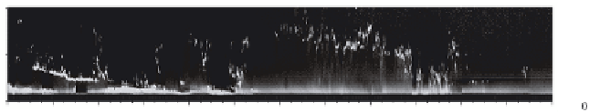
developed low pressure. Figure 3 is the result observed during 0-12 on
September 18, 2006. It was a windy day. Low clouds of less than 1 km
altitude appeared during 0-5 h. They raised the altitude up to 2 km during
5-8 h. The lidar echo from these clouds was sparse and largely fluctuating
in altitude. Sharp downturn of the cloud altitudes during 8-10 h was due
to the rainfall.
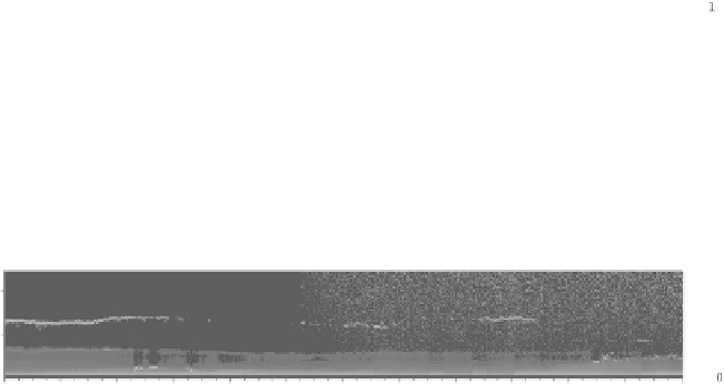
Examples of long-term temporal motion of the atmosphere are shown
in Fig. 4. Figure 4(a) is the result observed during 0-12 h local time on
3
1.5
0
0
2
4
6
8
10
12
Time [hour]
Fig. 3. 12-h cloud long-term observation result: September 18, 2006. Temp. 24
◦
C,
Hum. 82%.
(a)
6
3
0
4
6
8
10
12
0
2
Time [hour]
(b)
6
3
0
10
12
0
2
4
6
8
Time [hour]
Fig. 4. 12-h atmosphere long-term observation results. (a) September 21, 2006.
Temp. 24.7
◦
C, Hum. 59%, (b) December 23, 2006. Temp. 11.9
◦
C, Hum. 57%.