Geoscience Reference
In-Depth Information
6.2
. Rainy weather case
During the precipitation, the cloud base almost touches the ground in both
summer and winter. Nevertheless there is some seasonal difference in the
observed lidar profiles.
6.2.1
. Summer case
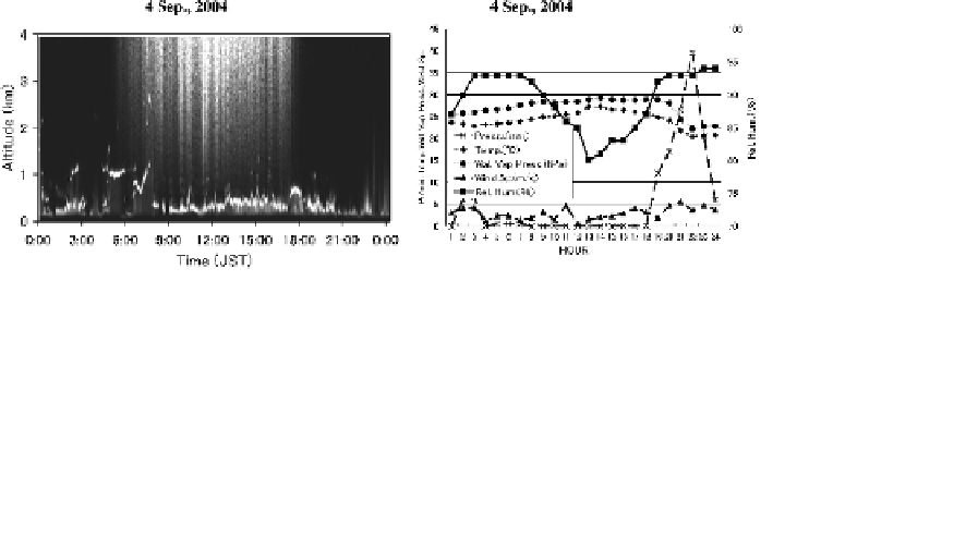
An example of 4 September, 2004 is shown in Fig. 5. The annually
largest precipitation of 135.5 mm occurred on this day. Comparison of
Figs. 5(a) and 5(b) indicates that the cloud indeed touches the ground
during the precipitation period (2:00-3:00 and 19:00-24:00), when it is seen
from the radar picture (not shown) that the cumulonimbus cloud covers
Chiba prefecture moving from north-east to south-west. From 9:00 to 19:00,
the cloud stays at a lower altitude (roughly 500 m), and the lidar signal that
indicates the cloud base height fluctuates largely on a bad weather day. The
weather map on this day shows that the stationary frontline stays off-shore
of the Chiba prefecture.
6.2.2
.Wintercase
As an example of winter precipitation, Fig. 6 shows the data observed on
16 January, 2005. The total daily precipitation was 66.5 mm. The rain was
almost over until 7:00. After that, the precipitation of roughly 1 to 2 mm
lingered until the evening. The temperature was almost constant around
5
◦
C-7
◦
C.
Fig. 5. Rainy weather case on 4 September, 2004. (a) Lidar data — The cloud base
height touches the ground during the precipitation. (b) Diurnal variation of precipitation,
temperature, relative humidity, water vapor pressure, and wind velocity.