Geoscience Reference
In-Depth Information
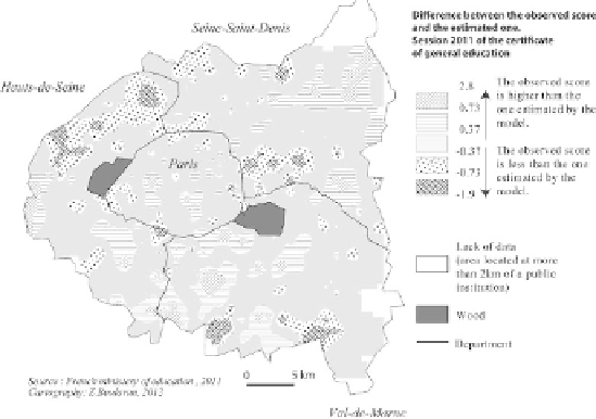
allows assessing the spatial variability of results at the regional level and identifying
the concentrations of schools with similar values. That of the North-West of the
region is rather significant, underlining an area where almost all schools record
lower grades to what would be expected from the model. The picture that can be
seen is one of an area with strong social discontinuity within the region, whose
effects are underestimated by the model. Undoubtedly, other effects which are not
easily measurable can be added to this such as the leakage of good students at the
school level, the inequalities of school funding and possible inequalities in grading
(diploma grading maintained at an infraregional scale).
2.3.4.4.
Step 4: to identify the processes leading to a varyingly significant school
segregation
The development of a simulation model is useful in order to identify the
processes in play in school segregation. It will permit us to differentiate between the
respective impact of the unequal distribution of the population according to its social
profile at the place of residence, of the practices of schools' heads with regard to the
selection of pupils; and finally, that of the practices of students' families in terms of
school choice. The multiagent system formalism allows, therefore, creating an
artificial world populated with students and schools led by school heads. The
objective is then to determine, in order to test them, the choice rules of
student-
agents
and the selection policies of
school heads-agents
[FRA 14b]. From this
model, different scenarios can be implemented (for example, more or less strict
school district mapping policy), the benefit being to be able to evaluate the final
configurations by comparison.
Figure 2.14.
Spatial organization of residuals between the observed
and modeled grade in Paris and close outskirts