Geoscience Reference
In-Depth Information
The lows intensify and reach the ground near the
coastline due to convection that is enhanced by onshore
winds forced over steep topography at the coast.
Topographic control
also deflects low-level easterlies
towards the equator, causing convergence and convec-
tion that can explode the formation of the cyclone.
Some lows become 'bombs', developing rapidly within
a few hours. This explosive development occurs when
pressure gradients reach 4 hPa per 100 km. Convection
of moisture-laden air is enhanced by cold inshore water
that maximizes condensation and the release of latent
heat. Along the east Australian coastline, the magnitude
of the sea-surface temperature anomaly does not
appear to be important in triggering a bomb. Rather,
the temperature gradient perpendicular to the coast
(the zonal gradient) is the crucial factor. This gradient
must be greater than 4°C per 0.5° of longitude, within
50 km of the coastline, for a low to intensify.
They may become warm-cored, obtain central pressures
below 990 hPa, develop an 'eye' that appears on satellite
images (Figure 3.16), and generate wind speeds in
excess of 200 km hr
-1
. These 'eye' structures have been
detected off the east coast of both Australia and the
United States. Once formed, the lows travel poleward
along a coastline, locking into the location of warmest
water. Such systems can persist off the coastline for up
to one week, directing continual heavy rain onto the
coast, producing a high storm surge, and generating
waves up to 10 m in height. Heaviest rainfalls tend to
occur towards the tropics, decreasing with increasing
latitude. This rainfall pattern shifts towards the equator
from summer to winter, reflecting the intensification
and seasonal movement of high-pressure systems.
East coast lows have produced exceptional storms.
The Ash Wednesday storm of 7 March 1962 in the
United States and the 25 May 1974 storm in Australia
are classic examples of this type of event. The most
recent, significant, east-coast lows to occur in the United
States were the Halloween storm of 28-31 October
1991 (The Perfect Storm), and the 21-22 December
1994 storm. The latter 'turned on' explosively, reaching
a central pressure of 970 hPa, developed a warm core
with attendant 'eye' structure, and generated winds of
160 km hr
-1
and waves 11.9 m high. These events are
further described below.
United States Ash Wednesday storm of
7 March 1962
(Dolan & Hayden, 1983; Nalivkin, 1983)
North America has experienced many severe, extra-
tropical storms. For instance, in 1868-1869, cyclonic
storms on the Great Lakes sank or damaged more than
3000 ships and killed over 500 people. However, the
Ash Wednesday storm of 7 March 1962 is considered
the worst storm recorded along the east coast of the
United States. At no time did the storm reach land as it
paralleled the coast some 100 km offshore. Its passage
along the coast took four days, with waves exceeding
4 m in height for most of this time. In the decades
leading up to the storm, housing development had
taken place on barrier islands along the coast. The
destruction of the storm was immense. Whole towns
were destroyed as storm waves, superimposed on a
storm surge of 1-2 m, overwashed barrier islands
(Figure 3.17). The loss of life was minimal since most of
the damage occurred to summer homes in the winter
season. Coastal retreat was in the order of 10-100 m.
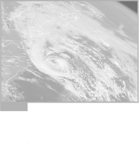
Infrared satellite image of the Halloween storm of October
1991 off the north-east coast of the United States. The
storm developed as an east-coast low and, shortly after
this photograph was taken, was reclassified as a tropical
storm (source: McCowan, 2001).
Fig. 3.16
East coast lows develop preferentially at night, at
times when the maritime boundary layer is most
unstable. East coast lows tend to form in late autumn or
winter when steep sea-surface temperature gradients
are most likely. However, they are not necessarily
restricted to these times, and can occur in any month of
the year. In Australia, a 4.5-year cycle is apparent in
records of these storms over the last forty years, with a
tendency for such lows to develop in transition years
between ENSO and La Niña events. In extreme cases,
the lows can develop the structure of a tropical cyclone.