Geoscience Reference
In-Depth Information
developed within the trade winds. On surface charts,
this wave is evident as an undulation in isobars parallel
to degrees of latitude.
Fourth, while easterly waves begin rotation, Coriolis
force has to be sufficient to establish a vortex. Cyclones
rarely form within 5° of the equator. Nor can
cyclones cross the equator, because cyclones rotate in
opposite directions in each hemisphere. Since obser-
vations began (in 1886 in the Atlantic and 1945 in the
Pacific), only two tropical cyclones - Typhoon Sarah in
1956 and Vamei in 2001 - have traveled within 3° of the
equator. Typhoon Vamei was unprecedented in that
its center came within 1.5° of the equator east of
Singapore and its zone of convection actually spilled
across the equator into the southern hemisphere. This
tropical cyclone's development was forced by a strong
mobile polar high that swept out of China into the
tropics.
Fifth, cyclones cannot be sustained - unless the land
is already flooded with water - at temperatures above
24°C because they are dependent upon transfer
of heat, from the surface to the upper atmosphere,
through the process of evaporation and release of
latent heat of condensation.
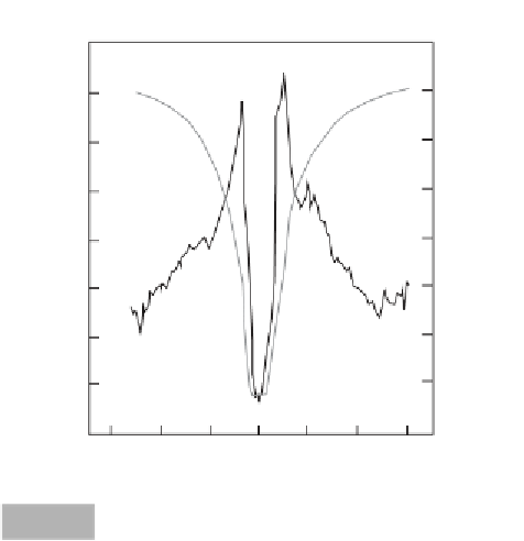
Sixth, tropical cyclones must form an '
eye
' structure
(Figure 3.5). If the convective zone increases to around
10-100 km distance, then subsidence of air takes place
in the center of the zone of convection, as well as to
the sides. Subsidence at the center of uplift abruptly
terminates convection, forming a 'wall'. Upwardly
spiraling convection intensifies towards this wall, where
surface winds become strongest. Once the convective
wall forms with subsidence in the core, the cyclone
develops its characteristic 'eye' structure. Subsidence
causes stability in the eye, cloud evaporates, and calm
winds result. The 'eye' is also the area of lowest pressure.
Seventh, cyclones cannot develop if there are
substantial winds in the upper part of the troposphere.
If horizontal wind speed aloft increases by more than
10ms
-1
over surface values, then the top of the con-
vective column is displaced laterally, and the structure
of the 'eye' cannot be maintained. Cyclones tend to
develop equatorward of, rather than under, the direct
influence of strong westerly winds.
Finally, the central pressure of a tropical cyclone
must be below 990 hPa. If pressures are higher than
this, then uplift in the vortex is not sufficient to
maintain the 'eye' structure for any length of time.
Some of the lowest pressures recorded for tropical
cyclones are presented in Table 3.1. The record low
pressure measured in a tropical cyclone in the Pacific
was 870 hPa in Typhoon Tip, north-east of the Philip-
pines, in October 1979. In North America, Hurricane
Gilbert in September 1988 produced the lowest
pressure of 880 hPa just before making landfall over
Jamaica. Note that cyclones with the lowest pressure
are not always the most destructive in terms of the loss
of human lives. This is mainly owing to the fact that not
all cyclones occur over populated areas.
Mag
nitude and frequency
80
1020
(Dvorak, 1975; Simpson & Riehl, 1981; Gray, 1984;
Donnelly et al., 2001; Ananthaswamy, 2003; Australian
Bureau of Meteorology, 2003)
1000
60
Tropical cyclones occur frequently. Figure 3.3 also sum-
marizes the average number of cyclones per year world-
wide in each of seven main cyclone zones. While the
numbers in any one zone appear low, when summed
over several decades, cyclone occurrence becomes very
probable for any locality in these zones. For example,
consider Hurricane Hazel, which I witnessed as a child
in 1954 when I was living at the western end of Lake
Ontario, Canada - a non-cyclone area 600 km from the
Atlantic Ocean. Hurricane Hazel was a rogue event and
is still considered the worst storm witnessed in southern
Ontario. This cyclone not only traveled inland, but it also
crossed the Appalachian Mountains, which should have
diminished its winds and rainfall. In fact, Hurricane
980
40
960
20
Wind
Pressure
The 'wall'
0
940
150
100
50
0
50
100
150
Distance from center of cyclone (km)
Wind and pressure cross sections through Hurricane Anita,
2 September 1977 (based on Sheets, 1980).
Fig. 3.5