Geoscience Reference
In-Depth Information
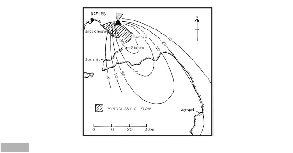
Naples
N
Herculaneum
Pompeii
Stabiae
Sorrento
Pyroclastic flow
Agropoli
0
10
20
30 km
Location map of Mt Vesuvius (Blong, ©1984, with permission Harcourt Brace Jovanovich Group, Australia).
Fig. 11.7
took three days before it was light enough to recover
his body. The pyroclastic ash falls buried Stabiae and
Pompeii to depths of 2 and 3 m, respectively. Most of
the residents of Pompeii appear to have fled, but
10 per cent were literally caught dead in their tracks by
the pyroclastic flows that climaxed the eruption. Her-
culaneum was also affected by the tephra fallout but, in
the latter stages of the eruption, was engulfed by a
mudflow 20 m thick. This lahar appears to have been
caused by groundwater expulsion as the caldera
collapsed.
The eruption marks one of the first volcanic disas-
ters ever documented. The sequence of events at
Vesuvius has been labelled a Plinian-type eruption
after Pliny's descriptions. Many of the buildings in
Pompeii and Herculaneum protruded above the ash.
The buildings were ransacked of valuables, dismantled
for building materials, and subsequently buried by
continued eruptions. The ash reverted to rich agricul-
tural land and Pompeii was forgotten. It was not until
1699 that Pompeii was rediscovered and excavated.
Vesuvius has continued to erupt aperiodically until the
present day. Subsequent major eruptions occurred in
203, 472, 512, 685, 787 and five times between 968 and
1037 AD. It then remained dormant for 600 years until
1630, when it produced extensive lava flows that killed
700 people. The last major eruption in 1906 produced
tephra up to 7 m thick on the north-east side of the
mountain. About 300 people were killed, mainly under
collapsing roofs. If the 79 AD eruption recurred today,
over 1 500 000 people would be affected.
Kra
katau (26-27 August 1883)
(Verbeek, 1884; Latter, 1981; Self & Rampino, 1981;
Nomanbhoy & Satake, 1995; Winchester, 2003)
The eruptions of Tambora and Krakatau in the
nineteenth century make Indonesia, with its dense
population, one of the most hazardous zones of
volcanic activity in the world. Krakatau lies in the
Sunda Strait between Sumatra and Java, Indonesia
(Figure 11.8). The Javanese
Book of Kings
describes an
earlier eruption that generated a sea wave that
inundated the land and killed many people in the
northern part of Sunda Strait. Krakatau had last been
active in 1681 and, during the 1870s, the volcano
underwent increased earthquake activity. In May of
1883, one vent became active, throwing ash 10 km
into the air. By the beginning of August, a dozen
Vesuvian-type eruptions had occurred across the island.
On 26 August, loud explosions recurred at intervals of
ten minutes, and a dense tephra cloud rose 25 km
above the island. The dust particles formed nuclei for
water condensation and muddy rain fell on adjacent
islands. The explosions could be heard throughout the
islands of Java and Sumatra. In the morning and later
that evening, small tsunami waves 1-2 m in height
swept the strait striking the towns of Telok Betong on
Sumatra's Lampong Bay, Tjaringin on the Java coast