Geoscience Reference
In-Depth Information
on Mt Rainier in Washington State 5000 years ago had
a volume of 1.9
4-8ms
-1
with peak discharges of 200-1200 m
3
s
-1
. A
few lahars reached speeds of 11 m s
-1
, with peak
discharges of 5000 m
3
s
-1
. Lahars were triggered by as
little as 6 mm of rainfall in half-an-hour. By the end of
the monsoon season, these lahars had moved about
0.9 km
3
of sediment and buried 300 km
2
of lowland.
The 1992 monsoon season yielded over 2000 mm of
rain that generated lahars that moved 0.5-0.6 km
3
of
sediment. Typically, 1000 m
3
of ash was removed from
each square kilometer of upland watershed by each
millimeter of rainfall. Each subsequent monsoon
season reiterated the process but with diminishing
volumes of sediment being transported. Because of
the installation of warning systems, the lahars after the
main eruption killed few people.
Because lahars are restricted to topographic lows,
they can be predicted in advance. The build-up of
tephra on a volcano's slopes can be easily measured, so
that steps can be taken to evacuate people in threat-
ened areas. After the Usu eruption in 1977 in Japan, it
was calculated that tephra deposits thicker than 0.5 m,
on slopes longer than 300 m and steeper than 17-18°,
would require only 20 mm of rain at a rate of
10 mm hr
-1
to initiate lahars. The 86 lahars that
occurred afterwards closely followed these predictions.
In New Zealand, lahars threaten the Whakapapa ski-
field situated on the north-west slopes of Mt Ruapehu.
Here, seismometers have been installed to detect small
earth movements indicating the start of a lahar. These
trigger alarms on the ski-fields giving skiers 5-10
minutes to ski out of valleys. While lahars are very
common and can reach velocities in excess of
20 km hr
-1
, they can be prevented in some cases.
Unfortunately, lahars can also be initiated by erosion of
old tephra deposits years, or decades, after the original
eruption has taken place. For instance, Mt Rainier was
affected by a lahar in 1947 even though no volcanic
eruption has been recorded historically.
10
9
m
3
and flowed 60 km from the
summit. Other lahars preserved in the geological
record in the United States have extended over
5000-31 000 km
2
. Secondary lahars following the
Plinian eruption of Mt Pinatubo in the Philippines in
June 1991 left more than 50 000 persons homeless, and
disturbed the livelihoods of 1 400 000 people in 39
towns and four large cities over an area of 1000 km
2
(Figure 11.5). The eruption was one of the largest of
the twentieth century and culminated on 15 June in an
explosive eruption that caused the summit to collapse
into a 2.5 km diameter caldera. Pyroclastic flows
exceeded 5-6 km
3
and spread up to 16 km from the
volcano over an area of 400 km
2
. The final eruption
discharged 3.4-4.4 km
3
of ash. On the day of the
climactic eruption, Typhoon Yunya passed close to
the volcano. First its winds scattered tephra to a thick-
ness of 10-33 cm over an area of 2000 km
2
, second its
rain soaked into the ash and caused many buildings to
collapse and, third, runoff turned the pyroclastic flows
into enormous lahars. The following monsoon rains
continued the threat, repeatedly generating hot lahars
that buried towns and agricultural land under 5-30 m
of ash, destroyed bridges, and cut roads. A typical lahar
was 2-3 m deep and 20-50 m wide. It consisted
of 50 per cent ash moving as slurry at velocities of
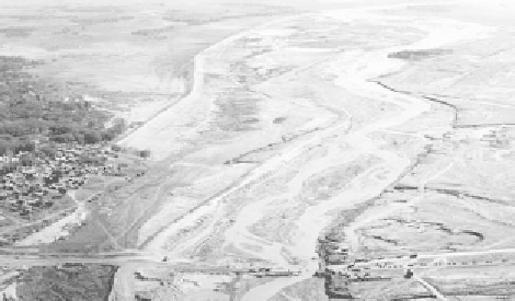
Lahar at Bamban following the eruption of Mt Pinatubo in
June 1991. The lahar has cut the main road linking major
cities in the north. As well, it has caused vertical accretion
of the river channel. To prevent sediment-laden waters
spilling across the floodplain and into the town, levees
have been built to contain the lahar (photo by Cees J. van
Western, International Institute for Aerospace Survey and
Earth Sciences, The Netherlands. Taken from NOAA's
National Geophysical Data Center hazard photos
<http://www.ngdc.noaa.gov/seg/hazard/slideset/36/
36_728_slide.shtml>).
Fig. 11.5
Glac
ier bursts or Jökulhlaups
(Halldórsson & Brandsdóttir, 1998)
Of particular danger during a volcanic eruption is the
melting of glaciers or snowfields by hot lava or gases.
The water can be subsequently heated and mixed with
mud debris to form a steaming hot lahar. These events
are termed jökulhlaups, an Icelandic word meaning
'glacier bursts'. Jökulhlaups are restricted mainly to
Iceland and the Andes; however, they can occur
elsewhere. For example, the Mt St Helens lahars were