Geoscience Reference
In-Depth Information
magnitude. For example, both tsunami scales contain
negative numbers and peak around a value of 4.0.
Tsunami waves clearly carry quantitative information
about the details of earthquake-induced deformation of
the seabed in the source region. Knowing the tsunami
magnitude, M
t
, it is possible to calculate the amount of
seabed involved in its generation using the following
formula:
Disa
ster descriptions
(Cornell, 1976; Myles, 1985; Bryant, 2001)
Over the past two thousand years there have been
462 597 deaths attributed to tsunami in the Pacific
region. Of these deaths, 95.4 per cent occurred in
events that killed more than one thousand people each.
The number of deaths is recorded in Table 10.5 for
each of the main causes of tsunami, while the events
with the largest death tolls are presented in Table 10.6.
M
t
= log
10
S
t
+ 3.9
(10.3)
where
S
t
= area of seabed generating
a tsunami (m
2
)
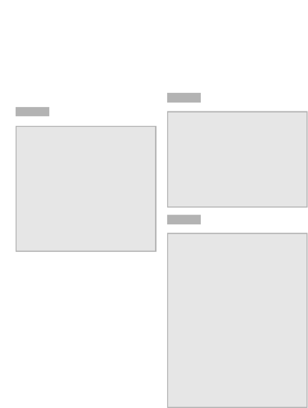
Causes of tsunami in the Pacific Ocean region over the
last 2000 years.
Table 10.5
Soloviev's scale of tsunami magnitude (source: from
Horikawa and Shuto, 1983).
Table 10.4
Number % of Number % of
Cause of events events of Deaths deaths
Landslides 65 4.6 14,661 3.2
Earthquakes 1,171 82.3 390,929 84.5
Volcanic 65 4.6 51,643 11.2
Unknown 121 8.5 5,364 1.2
Total 1,422 100.0 462,597 100.0
Source: National Geophysical Data Center and World
Data Center A for Solid Earth Geophysics (1998) and
Intergovernmental Oceanographic Commission (1999).
Tsunami
Mean run-up
Maximum run-up
magnitude
height (m)
height (m)
-3.0
0.1
0.1
-2.0
0.2
0.2
-1.0
0.4
0.4
0.0
0.7
0.9
1.0
1.5
2.1
2.0
2.8
4.8
2.5
4.0
7.9
3.0
5.7
13.4
Large death tolls from tsunami in the Pacific Ocean
region over the last 2000 years.
Table 10.6
3.5
8.0
22.9
4.0
11.3
40.3
4.5
16.0
73.9
Date Fatalities Location
22 May 1782 50,000 Taiwan
27 August 1883 36,417 Krakatau, Indonesia
28 October 1707 30,000 Nankaido, Japan
15 June 1896 27,122 Sanriku, Japan
20 September 1498 26,000 Nankaido, Japan
12 August 1868 25,674 Arica, Chile
27 May 1293 23,024 Sagami Bay, Japan
4 February 1976 22,778 Guatemala
29 October 1746 18,000 Lima, Peru
21 January 1917 15,000 Bali, Indonesia
21 May 1792 14,524 Unzen, Ariake Sea,
Japan
24 April 1771 13,486 Ryukyu Archipelago
22 November 1815 10,253 Bali, Indonesia
May 1765 10,000 Guanzhou, South
China Sea
16 August 1976 8,000 Moro Gulf, Philippines
Source: National Geophysical Data Center and World
Data Center A for Solid Earth Geophysics (1998) and
Intergovernmental Oceanographic Commission, (1999).
The above scales imply that the size of a tsunami
should increase as the magnitude of the earthquake
increases. This is true for most
teleseismic tsunami
in
the Pacific Ocean; however, it is now known that many
smaller earthquakes can produce large, devastating
tsunami. The Great Meiji Sanriku earthquake of 1896
and the Alaskan earthquake of 1 April 1946 were of
this type. The Sanriku earthquake was not felt widely
along the adjacent coastline. Yet, the tsunami that
arrived thirty minutes afterwards produced run-ups
that exceeded 30 m in places and killed 22 000 people.
These types of events are known as
tsunami earth-
quakes
. Submarine landslides are thought to be one of
the reasons why some small earthquakes can generate
large tsunami; but this explanation has not been
proven conclusively. Presently, it is believed that
slow rupturing along fault lines causes tsunami
earthquakes.