Geoscience Reference
In-Depth Information
Napoleonic Wars in 1812, San Francisco during the
1906 earthquake, and Dresden and Hamburg during
the Second World War. The outbreaks of fire were
minor to begin with, but they occurred throughout
both cities in large numbers, mainly because the
earthquake occurred at lunchtime when many open
fires were being used for cooking. Within half-an-
hour, over 200 small fires were burning in Yokohama
and 136 were raging in Tokyo. The rubble of collapsed
buildings in the streets and cracked water mains
compounded the difficulty in dealing with the fires.
Firefighters could neither get to the fires nor
obtain a reliable water source to extinguish them.
Once the fires raged, the cluttered streets hampered
evacuation. In Yokohama, 40 000 people fled to an
open area around the Military Clothing Depot, which
was subsequently engulfed in flames. All these people
died from the searing heat or suffocation caused by
the withdrawal of oxygen.
The spread of fire was aided initially by strong
tropical cyclone winds. In the chapter on tropical
storms, it was pointed out that the earthquake was
probably triggered by the arrival of a tropical cyclone
the previous day. The calculated change in load on the
Earth's crust because of the pressure drop, and
the increased weight of water from the storm surge,
was 10 million tonnes km
-2
. The fires were exacerbated
by the development of strong winds generated by the
cyclone in the lee of surrounding mountains. These
The
Japanese earthquake hazard
(Hodgson, 1964; Holmes, 1965; Hadfield, 1992; EQE,
1995; Bardet et al., 1997)
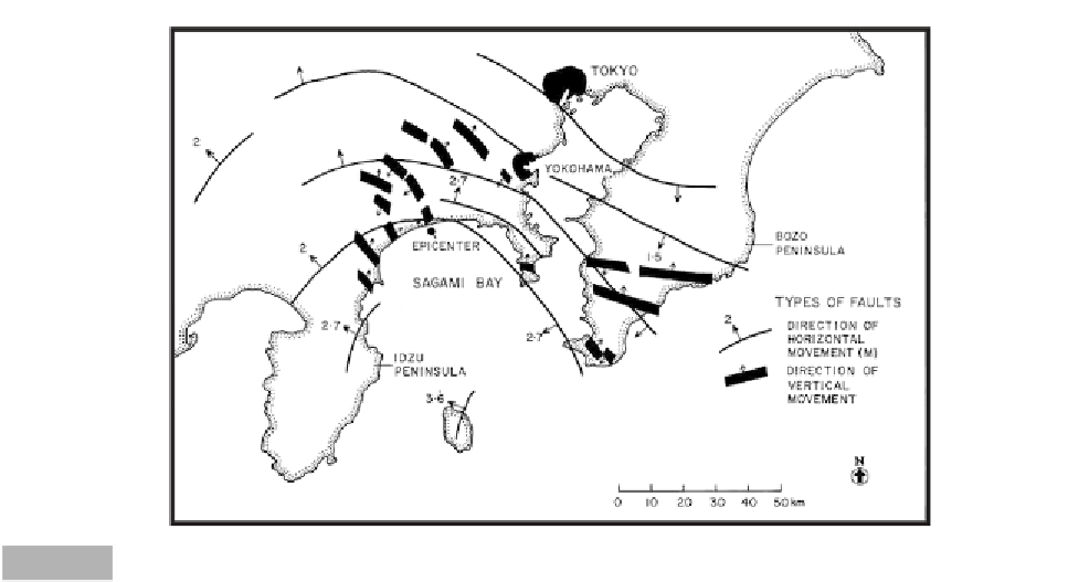
The most notable earthquake in Japan in the last
century occurred on 1 September 1923 in Sagami Bay,
50 km south-west of Tokyo (Figure 10.8). Known as
the Great Kanto Earthquake, the crustal movements
twisted the mainland in a clockwise direction, with
a maximum horizontal displacement of 4.5 m and a
vertical drop of 2 m. Until the Alaskan earthquake,
these were some of the greatest crustal shifts
recorded. Within the bay itself, changes in elevation
were much larger owing to faulting, compaction, and
submarine landslides. Measurements after the earth-
quake indicated that parts of the bay had deepened by
100-200 m with a maximum displacement of 400 m.
The Tokyo earthquake immediately collapsed over a
half million buildings and threw up a tsunami 11 m in
height around the sides of Sagami Bay. However,
these events were not responsible for the ultimately
large death toll, because many of the collapsed build-
ings consisted of lightweight materials. The deaths
resulted from the fires that immediately broke out in
the cities of Tokyo and Yokohama, and raged for three
days, destroying over 50 per cent of both cities. The
fires rate as one of the major urban conflagrations in
history - on the same scale as fires that destroyed
London in 1666, Chicago in 1871, Moscow during the
Tokyo
2.0
Yokohama
2.7
Bozo
Peninsula
1.5
Epicenter
Fault displacement
Direction of
horizontal
movement (m)
Direction of
vertical
movement
Sagami Bay
2.0
2.7
2.7
Idzu
Peninsula
3.6
N
0
10
20
30
40
50 km
Distribution of faulting for the Tokyo earthquake, 1 September 1923 (from Holmes, 1965).
Fig. 10.8