Geoscience Reference
In-Depth Information
(a)
Ireland
Ireland
51°N
48°N
7°W
12°W
12°W
7°W
14
15
16
17
18 °C
0.2
0.5
2
4
mg Chl m
-3
(b)
0
26.2
40
80
0
40
80
3
6
9
Time (hours)
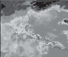
Figure 10.16
See
colour plates version
of (a). (a) Composite images of the Celtic Sea,
June 13-19, 2004 courtesy of NEODAAS, Plymouth Marine Laboratory, UK. The left panel is
sea surface temperature collected by AVHRR, the right panel is sea surface chlorophyll taken
by MODIS. The bold contour line marks the 200 metre isobath at the shelf edge, the thin
contour is the 2000 metre isobath. (b) A cross-shelf edge section of density (kg m
3
, upper
panel) and chlorophyll (mg m
3
, lower panel) observed using a Batfish towed, undulating CTD
system along the bold line marked in (a), adapted from Pingree et al. (
1982
), with
permission from Elsevier. The research vessel speed was about 8 knots (15 km h
1
).


Search WWH ::

Custom Search