Geoscience Reference
In-Depth Information
50ºN
North America
Gulf of
Mexico
10ºN
120ºE
60ºE
(a)
30ºN
Atchafalaya R.
Mississippi R.
1
29ºN
1
3
50 km
93ºE
91ºE
89ºE
Longitude
(b)
0
1
-10
-20
-30
0
10
20
30
40
50
Distance (km)
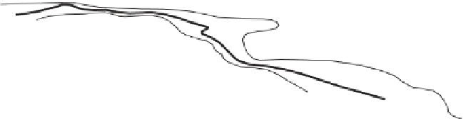
Figure 9.19
Distributions of dissolved oxygen (mg l
1
) in the 'dead zone' off the coast of
Louisiana and Texas. (a) Bottom water dissolved oxygen in mid-summer 1993. (b) A section
across the shelf (dotted line in (a)) showing the low dissolved oxygen limited to the deeper
water. This section was taken in August 1990 during upwelling favourable winds, which have
courtesy of Annual Reviews.
sediments become stressed at 1 mg l
1
, and die when oxygen falls below about 0.5 mg
l
1
. The scale of this problem is such that a task force, led by the U.S. Environmental
Protection Agency, has been set up to plan and implement the reduction of nitrogen
loading on the Mississippi; considering the size of the Mississippi catchment, which


Search WWH ::

Custom Search