Geoscience Reference
In-Depth Information
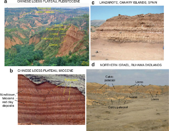
Fig. 16.1
Gallery of loess exposures from around the world, 1: (
a
) dissected loess plateau
landscape and Pleistocene loess exposed at Luochuan, Chinese Loess Plateau - “L” prefix indicates
loess units, and “S” prefix indicates paleosols; (
b
) Miocene Red Clay on the Chinese Loess Plateau
(section is
10 m thick, light bands are aeolian clay, and dark bands are paleosols) (photo by
Youbin Sun); (
c
) loess-like (fluvially and colluvially reworked) sediment exposed near Guatiza,
Lanzarote, Canary Islands, Spain (see von Suchodoletz et al. (
2009
) for detailed study); (
d
)
Pleistocene loess and paleosols exposed in the Ruhama badlands area, northern Negev Desert of
Israel
silt-sized aggregates (see discussion by S. Cattle below), (c) loess bodies extending
considerable distances from their sources, and/or (d) varying wind strengths over
time.
Loess thickness is highly variable. It can range from a few centimeters to
several hundred meters in thickness. Indeed, variability of loess thickness is
one of its advantages as a paleoclimate indicator, as we discuss below. Loess
deposits are commonly draped over preexisting landforms as a mantle, with thickest
accumulations in protected, low-lying areas or broad, flat, stable upland divides and
thinnest accumulations occurring on narrow, rounded hillcrests. Loess deposits can
be intercalated with other sorts of sediments, such as tephras, where there is active
volcanism, as is the case in Iceland, South America, Alaska, and New Zealand.
Commonly, multiple loess units are apparent in outcrop, separated by paleosols
that mark periods of cessation of loess deposition or at least periods when loess
sedimentation rates were greatly diminished.
Search WWH ::

Custom Search