Geoscience Reference
In-Depth Information
6.2
Large-Scale Circulations
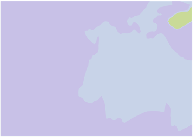
Many dust sources around the world are located in areas influenced by monsoon
circulations, most notably the Indian and West African monsoons. These regions
are characterised by a reversal of the mean wind direction from summer to winter,
associated with the formation of marked continental heat lows during the hottest
part of the year (marked 'L' in Fig.
6.1
). For the Indian summer monsoon, the
lowest mean-sea level pressure is typically found near the Pakistan-Indian border
around 30
ı
N, 73
ı
E. The strong interhemispheric pressure gradient to the subtropical
anticyclone over the southern Indian Ocean drives a powerful circulation with strong
and persistent winds affecting dust sources on the Horn of Africa, the eastern flank
of the Arabian Peninsula as well as in southern parts of Pakistan and northwestern
parts of India (marked by red lines in Fig.
6.1
). At the same time, there is a north-
south corridor of strong northerly winds across Turkmenistan, eastern Iran and
Afghanistan directed into the heat low, which is sometimes referred to as the “wind
of 120 days” (Middleton
1986
). There is a maximum occurrence of dust days with
Fig. 6.1
Boreal summer (June-August) average mean sea-level pressure (
shaded
) and 10 m vector
winds. The three main continental heat lows over West Africa, the Arabian Peninsula and the border
of India and Pakistan are marked with 'L's. Areas with strong inflow into these heat lows prone to
dust generation are marked in red. The plot is based on 1979-2012 ERA-Interim analyses produced
by the European Centre for Medium-Range Weather Forecasts (ECMWF)


Search WWH ::

Custom Search