Geoscience Reference
In-Depth Information
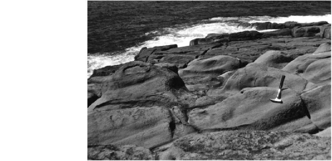
Fig. 3.20
Flutes developed on
the crest of a ramp 14 m above
sea level at Tura Point, New
South Wales Australia. The
depressions on the sides of the
flutes are cavettos. Flow from left
to right
downstream. V-shaped grooves have no sub-glacial equiv-
alent and can span a large range of sizes. For instance, at
Bass Point, New South Wales, V-shaped grooves over 30 m
wide
contemporary wave attack is one of the best indicators of
high-velocity tsunami flow over a bedrock surface.
On flat surfaces, longitudinal vortices give way to ver-
tical ones that can form hummocky topography and pot-
holes (Fig.
3.17
). Potholes are one of the best features
replicated at different scales by high-velocity tsunami flow.
While large-scale forms can be up to 70 m in diameter,
smaller features have dimensions of 4-5 m (Alexander
1932
; Baker
1981
; Kor et al.
1991
). The smaller potholes
also tend to be broader, with a relief of less than 1 m. The
smaller forms can exhibit a central plug, but this is rare
(Fig.
3.21
). Instead, the potholes tend to develop as flat-
floored, steep-walled rectangular depressions, usually
within the zone of greatest turbulence. While bedrock
jointing may control this shape, the potholes' origin as
bedrock-sculptured features is unmistakable because the
inner walls are inevitably undercut or imprinted with
cavettos. In places where vortices have eroded the con-
necting walls between potholes, a chaotic landscape of
jutting bedrock with a relief of 1-2 m can be produced. This
morphology—termed hummocky topography—forms
where flow is unconstrained and turbulence is greatest
(Bryant and Young
1996
). These areas occur where high-
velocity water flow has changed direction suddenly, usually
at the base of steep slopes or the seaward crest of headlands.
The steep-sided, rounded, deep potholes found isolated on
intertidal rock platforms, and attributed to mechanical
abrasion under normal ocean wave action, could be cata-
strophically sculptured forms. Intriguingly, many of these
latter features also evince undercutting and cavettos along
their walls.
and
spanning
approximately
10 m
in
relief
have
developed on slopes of more than 20.
The term flute describes long linear forms that develop
under unidirectional, high-velocity flow in the coastal
environment (Bryant and Young
1996
). These are notice-
able for their protrusion above, rather than their cutting
below, bedrock surfaces (Figs.
3.19
and
3.20
). In a few
instances, flutes taper downstream and are similar in shape
to rock drumlins and rattails described for catastrophic flow
in sub-glacial environments. In all cases, the steeper end
faces the tsunami, while the spine is aligned parallel to the
direction of tsunami flow. Flutes span a range of sizes,
increasing in length to 30-50 m as slope decreases. How-
ever, their relief rarely exceeds 1-2 m. Larger features are
called rock drumlins. The boulder trails at Tuross Head,
mentioned above, are constrained by flutes. Fluted topog-
raphy always appears on the seaward crest of rocky prom-
ontories where velocities are highest. Flutes often have
faceting or cavettos superimposed on their flanks. Faceting
consists of chiseled depressions with sharp intervening
ridges (Maxson
1940
). They represent either the impinge-
ment of vortices instantaneously upon a bedrock surface or
hydraulic hammering of rock surfaces by high-velocity
impacts. Cavettos are curvilinear grooves eroded into steep
or vertical faces by erosive vortices (Kor et al.
1991
). While
cavetto-like features can form due to chemical weathering
in the coastal zone, especially in limestones, their presence
on resistant bedrock at higher elevations above the zone of