Geoscience Reference
In-Depth Information
Table 3.1
Correspondence between the inferred age of anomalous
sand layers and dated tsunami events on the Sanriku coast of northeast
Honshu Island, Japan
Inferred age
Closest corresponding event
Source
1948
4 March 1952
Hokkaido
1930
3 March 1933
Sanriku
1905
5 June 1896
Sanriku
1887
9 May 1877
Chile
1861
13 August 1868
Chile
1853
23 July 1856
Sanriku
1843
20 July 1835
Sanriku
1805
7 January 1793
Sanriku
1787
29 June 1780
Kuril Islands
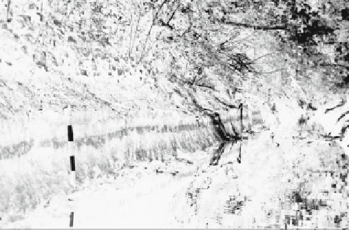
Fig. 3.5
Sand layer, deposited by tsunami, sandwiched between peats
at Cultus Bay, Washington State. The markings on the shovel are at
0.1 m intervals. The tsunami event was radiocarbon-dated from
Triglochin rhizomes in the upper peat at AD 1040-1150 (Huntley and
Clague
1996
)
1772
16 December 1763
Sanriku
1769
15 March 1763
Sanriku
1742
25 May 1751
Chile
1710
8 July 1730
Chile
Source From Minoura et al. (
1994
)
2000 years, revealing a recurrence interval of one major
event every 50 years. Not all events, though, may have been
preserved, because the recurrence interval since 1737
averages one tsunami event every 12.3 years. Along the
west coast of North America, anomalous sand layers are
trapped within peats, show sharp non-erosional upper con-
tacts, and erosional bottom ones (Atwater
1987
; Darienzo
and Peterson
1990
; Clague and Bobrowsky
1994
). The sand
layers are 1-30 cm thick (Fig.
3.5
) and similar in grain size
to beach and dune sands on the adjacent seaward coast.
Both optical luminescence dating of quartz sand and
radiocarbon dating of buried carbon indicate that a great
earthquake occurred along 700 km of the Cascadia sub-
duction zone 300 years ago (Darienzo and Peterson
1990
;
Huntley and Clague
1996
). The exact age has been inferred
from the recording of a tsunami in Japan on January 26,
1700 (Satake et al.
1996
) The Kwenaitchechat North
American Indian legend in
Chap. 1
referred to this event. At
least five other events have been identified, with three of the
largest occurring somewhere between 600 and 900; 1000
and 1400; and 2800 and 3200 years ago. At Crescent City,
California, up to 12 additional sand layers have been found
in a peat bog (Aalto et al.
1999
). This record is similar to the
Kamchatka Peninsula in frequency. Interestingly, the tsu-
nami from the Great Alaskan Earthquake of March 27, 1964
only produced a thin sand layer about a centimeter thick
here. The lack of cross bedding in the units indicates
deposition out of turbulent suspension, while alternation
within the same unit between sand and silty clay suggests
pulses of sediment entrainment, transport, and deposition.
Numerous paleo-studies have been carried out in the
Mediterranean region. In the Huelva Estuary in the Gulf of
Cadiz of Spain, five, thin, shelly beds characteristic of
tsunami deposition were found in thick, tidal muds (Morales
Older chronologies have been discovered. In a back
barrier lagoon at Lake Jusan on the northern end of Honshu
Island, facing the Sea of Japan, layers of medium sand
40 cm or more in thickness are sandwiched within organic
ooze (Minoura and Nakaya
1991
). Sedimentological anal-
ysis indicates that the sands originated from sand dunes or
the open ocean beaches. These deposits have been linked to
large tsunami events with wave heights in excess of 6 m
occurring at intervals of 250-400 years over the past
1800 years. On the Pacific coast of Honshu, on the Sendai
Plain, as many as five sand layers are sandwiched in peats
up to 4 km inland (Minoura and Nakaya
1991
; Minoura
et al.
2001
). Two of the upper layers can be correlated to
killer tsunami that swept over the plain in 869 and 1611.
The 869 event prophetically matches the extent of the
severe T ¯hoku Tsunami of March 11, 2011.
Without historical records, anomalous sand layers allude
to paleo-tsunami. Where multiple layers are present, then
recurrence intervals can be determined, especially along
coastlines that have only been settled in the last few cen-
turies. For example, on the southeastern coast of the
Kamchatka Peninsula of eastern Russia, sand layers are
preserved in peats or organic-rich alluvium (Pinegina et al.
1996
). These sequences also contain volcanic ash layers or
tephras that can be used to date the sequences. The tsun-
amigenic layers consist of coarse marine sand mixed with
gravel and pebbles in landward tapering sheets 2-3 cm
thick. The largest tsunami overrode terraces 15-30 m above
sea level up to 10 km from the coast. Many of the layers
show evidence of suspension transport of sediment, in some
cases aided by the passage of tsunami over frozen or icy
ground.
Forty
events
can
be
identified
over
the
past