Geoscience Reference
In-Depth Information
Depositional
Erosional
Sand layers
Impact marks
Drill holes
Sinuous grooves
Cavitation
features
Foraminifera and diatoms
Boulder floaters in sand
Dump deposits
Disturbed middens
Mounds, domes, ridges
Muschelbrüche, sichelwannen, V-shaped grooves
Flutes and rock drumlins
Facets and cavettos
Potholes and hummocky topography
Transverse troughs
Sedimentary
deposits
S-forms
Chevrons
Dune bedforms
Smear deposits
Boulders: stacked and imbricated
Turbidites
Ramps
Canyon drainage channels
Pools and cascades
Fluted promontories
Inverted keellike stacks
Sea caves, arches
Whirlpools and plugs
Sculptured
headland
features
Geomorphic
forms
Coastal barriers
Geomorphic
forms
Deltas
Truncated cliffs
Raised platforms
Toothbrush-shaped headlands
Atolls
Island Landscapes
Landscape
features
Fig. 3.2
Depositional and erosional signatures of tsunami
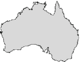
Fig. 3.3
Locations of coastline
around Australia showing the
most prominent signatures of
paleo-tsunami: a south coast of
New South Wales, b Cairns
coast, northeast Queensland, and
c northwest West Australia
110º
120º
130º
140º
150º
160º
(b)
-10º
Barrier
reef
Cooktown
-20º
Trinity
Opening
Grafton
Passage
Cow Bay
Oak
Beach
Cairns
Australia
-30º
050
100 km
-40º
(a)
Port
Stephens
Sydney
Wollongong
(c)
Cape Leveque
Shoalhaven
Delta
Jervis Bay
Batemans
Bay
Broome
Mystery
Bay
Pt. Samson
Exmouth
North West
Cape
Tura
Point
0
200 km
0
100
200 km