Geoscience Reference
In-Depth Information
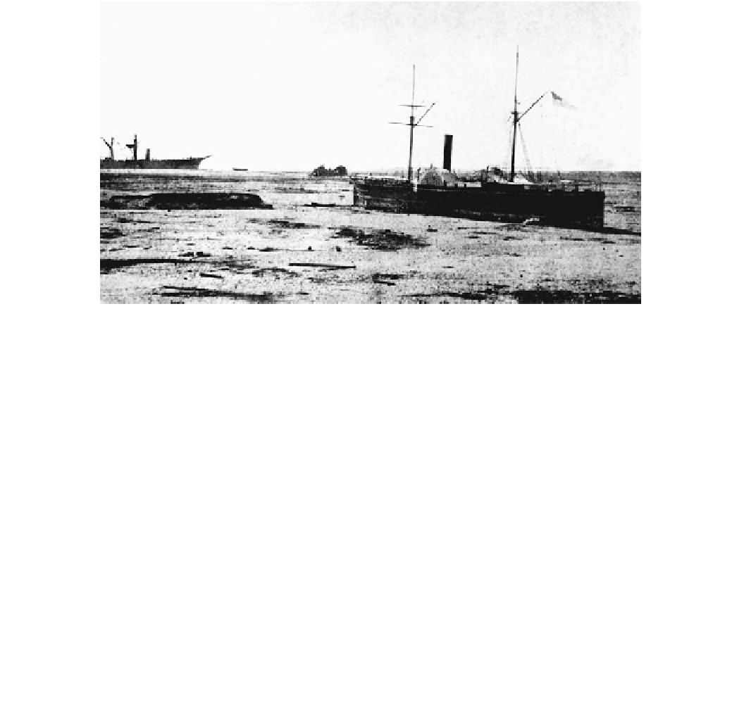
Fig. 2.11
The American warship Wateree in the foreground and the
Peruvian warship America in the background. Both ships were carried
inland 3 km by a 21 m high tsunami wave during the Arica, South
American event of August 13, 1868. Retreat of the sea from the coast
preceded the wave, bottoming both boats. The Wateree, being flat
hulled, bottomed upright and then surfed the crest of the tsunami wave.
The America, being keel-shaped, was rolled repeatedly by the tsunami.
Photograph courtesy of the United States Geological Survey. Source
Catalogue of Disasters #A68H08-002
2.5.2
Inland Penetration and Velocity
Runup
600 s
8
As a rough rule of thumb, the cross-sectional area of
coastline flooded by a tsunami is equal to the cross-sectional
area of water under the wave crest close to shore
(Fig.
2.13
). The bigger the tsunami, or the longer its wave
period, the greater the volume of water carried onshore and
the greater the extent of flooding. The maximum distance
that run-up can penetrate inland on flat and sloping coasts
can be calculated using the following formulae (Hills and
Mader
1997
; Pignatelli et al.
2009
):
500 s
6
400 s
100 s
200 s
300 s
4
2
0
Mean sea level
700 s
4
3
2
1
0
- 1
Distance from shore (km)
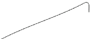
Fig. 2.12
Run-up of a tsunami wave onto a beach modeled using
shallow-water, long-wave equations. The model used a grid spacing of
10 m and 0.5 s time increments. The original sinusoidal wave had a
height of 3 m and a period of 900 s. Run-up peaked at 6 m above
mean sea level and penetrated 600 m inland on a 1 % slope. Based on
Mader (
1990
)
x
max
¼
H
ð
1
:
33
n
2
k
ð
2
:
14
Þ
x
max
¼
H
ð
1
:
33
n
2
k cos b
l
ð
2
:
15
Þ
where
x
max
= limit of landward incursion (m)
Manning's n mentioned. For developed land on flat coastal
plains, a tsunami with a height of 10 m at shore can pene-
trate 1.4 km inland. Exceptional tsunami with heights at
shore of 40-50 m can race 9-12 km inland. Only large
earthquakes, submarine landslides, and asteroid impacts
with the ocean can generate these latter wave heights. For
crops or pasture, the same waves could theoretically rush
inland four times further—distances of 5.8 km for a 10 m
high wave at shore and 36-49 km for the 40-50 m high
tsunami. The Indian Ocean Tsunami at Banda Aceh, Indo-
nesia in 2004 with a height of 10 m at shore reached these
predicted limits, traveling 5 km inland. Equation
2.14
, and
field research (Shuto
1993
), also indicates that the effect of
n
= Manning's n
k
= a constant
b
l
= slope of land surface
Very smooth terrain such as mud flats or pastures has a
Manning's n of 0.015. Areas covered in buildings have a
value of 0.03, and densely treed landscapes have a value of
0.07. The constant, k, in Eq.
2.14
has been evaluated for
many tsunami and has a value of 0.06. The equation
assumes that the run-up height equals the maximum depth
of the tsunami at shore. Using this value, the maximum
distance that tsunami can flood inland is plotted in Fig.
2.14
for
different
run-up
heights,
for
the
three
values
of