Geoscience Reference
In-Depth Information
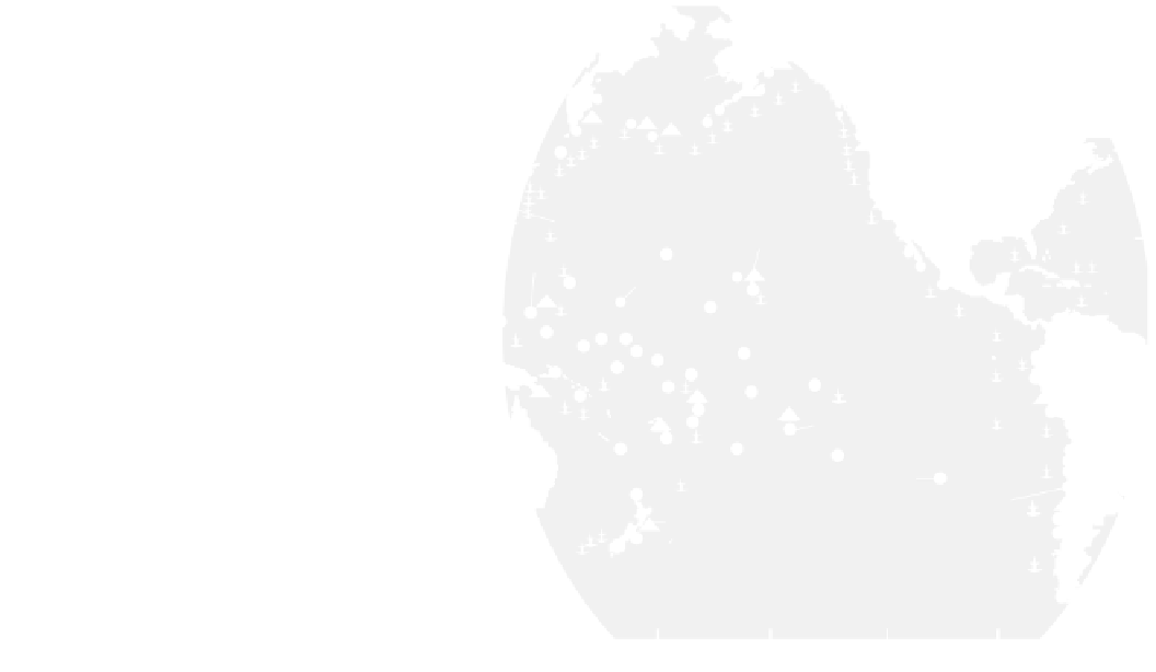
Fig. 10.6
Location of seismic
stations and tide gauges making
up the Pacific Tsunami Warning
System, DART buoy network,
and area of possible coverage of
the THRUST satellite warning
system. Sources Bernard
(1991)
,
González (
1999
).
http://www.
Seismic station
Tide guage
DART buoy - installed
North
America
60°
Palmer
DART buoy - planned
THRUST coverage
To k y o
Pacific Tsunami
Warning Center
30°
Guam
Wake Island
Hawaii
South
America
0°
Papeete
Australia
-30°
Easter Island
Valparaiso
Wellington
-60°
120°
150°
180°
-150°
-120°
-90°
-60°
has been detected, information is relayed to Honolulu where
a warning is issued. Anyone can receive these tsunami
warnings direct via e-mail by subscribing at
https://lists.
also possible to receive warnings via SMS on a mobile
phone or through social media at
http://ptwc.weather.gov/
subscribe.php
. After the warning, a request is issued to
member countries for observations of anomalous sea level
on tide gauges and DART buoys, lying in deep water,
scattered throughout the Pacific. These gauges and buoys
can be polled in real time. Once a significant tsunami has
been detected, its travel path and height are obtained from
pre-calculated models. If no tsunami of significance is
detected at tide gauges closest to the epicenter, the PTWC
issues a cancellation. At present, about one warning per
month is issued for the Pacific Ocean region for potentially
tsunamigenic earthquakes. The warnings are then integrated
into regional and local communication networks for dis-
semination to the public (Fig.
10.7
).
DART buoys combine a seabed transducer linked to a
surface buoy, which can transmit to a communications
satellite (Fig.
10.8
) (González
1999
). The transducers can
detect tsunami heights of only 1 cm in water depths of
6,000 m. This networking can be used to forewarn of local
tsunami, overcoming the necessity for long cable connec-
tions to shore that the Japanese experimented with unsatis-
factorily in the earlier 1980s. NOAA deployed six of these
deep ocean buoys before 2004 in a project known as Deep-
Ocean Assessment and Reporting of Tsunami (DART). The
2004 Indian Ocean Tsunami changed dramatically the
deployment of DART buoys. The United States realised
immediately that six buoys in the Pacific Ocean gave
insufficient coverage to provide adequate tsunami warnings
from all source regions in the Pacific. In addition, the United
States realised that its eastern and southeastern coastlines
were as vulnerable to tsunami as Sri Lanka and Thailand
were to the Sumatran event of 2004. An upgraded buoy,
DART II, was built linking tsunami wave detection in the
open ocean to land based stations via Iridium satellites.
Seven buoys were deployed in the Atlantic Ocean (Fig.
10.6
)
and integrated into NOAA's Weather Radio All Hazards
system and the Emergency Alert System to provide tsunami
warnings to the entire United States Atlantic coast, Gulf of
Mexico, Puerto Rico, the US Virgin Islands, and eastern
Canada. In addition, the number of buoys in the Pacific
Ocean was increased to 32, scattered around the Ring-of-Fire
earthquake source region. All buoys operated by the United
States in the Atlantic and Pacific Oceans were operational by
March 2008. This network has been supplemented by 14
other DART buoys in the Pacific Ocean operated by five
other countries: Australia, Russia, Japan, Ecuador and Chile.
There are also six buoys placed in the Indian Ocean near
zones of historically large, tsunamigenic earthquakes.
Surprisingly, no DART buoys have been placed in the
eastern North Atlantic despite the Lisbon earthquake being
one of the largest tsunamigenic earthquakes recorded.