Geoscience Reference
In-Depth Information
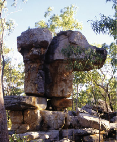
Fig. 9.15
Comet Rock,
Kalumburu, Western Australia.
The tail of the rock is orientated
310 to the NW. The painting of
the comet is 'Wandjinan' in age.
This rock lies about 5 km from
the ocean on a plain covered in a
layer of beach sand
started in the north of Australia and flooded the whole
country. Just as quickly as the land was flooded, it drained.
The Kimberley region is subject to some of the most
intense tropical storms in the world associated with winds in
excess of 300 km h
-1
and storm surges of 3.6 m (Nott
2004
). However, the coastline everywhere evinces either the
erosional effect of a catastrophic wave or its depositional
residue beyond the capacity of these extreme cyclones. At
Cape Voltaire, directly west of Kalumburu, a catastrophic
wave has truncated the ends of headlands and carved out a
ramp across columnar basalt (Fig.
9.18
a) (Bryant et al.
2007
). This ramp terminates about 20 m above sea level.
Little debris evacuated from the ramp is present either on the
ramp surface or offshore. Instead, the columnar basalt has
been broken into 5 m lengths, tossed over the 40 m high
headland and deposited on the sheltered lee slope above the
influence of storm waves such that individual blocks reflect
the direction of flow, 350 to the northwest (Fig.
9.18
b). In
the Great Sandy Desert, the wave eroded sand dunes from the
coastal plain, depositing shell debris and cobbles 30 km
inland in chevron-shaped ridges (Bryant and Nott
2001
).
South of Broome, at Point Samson, waves overrode a 60 m
high hill more than 500 m inland, depositing three layers of
boulder-laden sand 30 m thick on the lee side. In a valley
leading back from the coast, large mega-ripples with a
wavelength approaching 1,000 m, and consisting of cross-
bedded gravels, have been deposited up to 5 km inland. The
gravels contain well-rounded boulders over 1 m in diameter.
The tsunami overrode and breached 60-m-high hills up to
5 km inland. Smaller hills, 15 m high and lying 2 km from
the coast, were sculptured into hull-shaped forms with evi-
dence of extreme plucking of bedrock, leaving in one case a
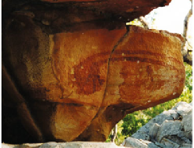
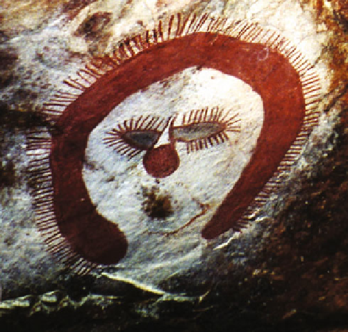
Fig. 9.16
A typical Wandjina face painted on rock shelters through-
out the Kimberley. The barbed hood represents lightning. Wandjina do
not have a nose or mouth. The comet-like symbol in place of the nose
represents
power.
Wandjina
do
not
need
a
mouth
because
their
knowledge is greater than what can be spoken
It is possible to date the timing of this mega-tsunami in
the Kimberley using radiocarbon dating of shell (Fig.
9.19
).
Fifteen dates exist along the Northwest Australian coastline
with two from the Kimberley region. The most recurrent
age centers between 1620 and 1730 with a defined peak at
1690, indicating that the effects of a mega-tsunami that
occurred around the end of the seventeenth century can now
be traced along 1500 km of coastline. This age agrees with