Geoscience Reference
In-Depth Information
120°
140°
160°
180°
0°
Kimberley
Gulf of
Carpentaria
D
140°
160°
180°
-20°
Glasshouse Mtns
Australia
Australia
-30°
Lord Howe Island
Wilcannia
Sydney
New
Zealand
Jervis Bay
Sydney
North Island
Tasman
Sea
Tura Pt.
Kangaroo
Island
-40°
Tasman
Sea
-40°
New
Zealand
Tapanui
Warrnambool
South Island
Tollman's
Deluge Comet
impact site
Stewart
Is.
Stewart Island
B
C
-50°
Mahuika Comet
Impact Site
(a)
(b)
-60°
166°
167°
168°
169°
-46°
122°
124°
126°
128°
Invercargill
Cape Voltaire
-14°
Mason Bay
-47°
Kalumburu
Walcott Inlet
Stewart
Island
Cape
Leveque
-16°
Kununurra
inferred path
based on tektites
-48°
Snares Islands
Mahuika
impact
crater
Broome
(d)
(c)
-18°
-49°
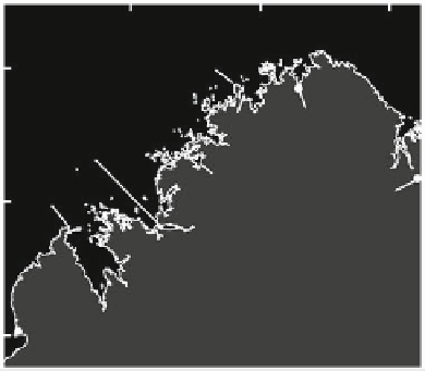
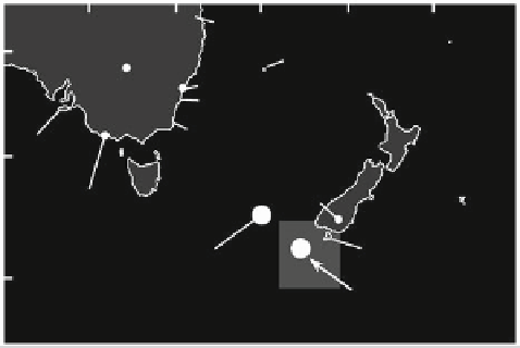
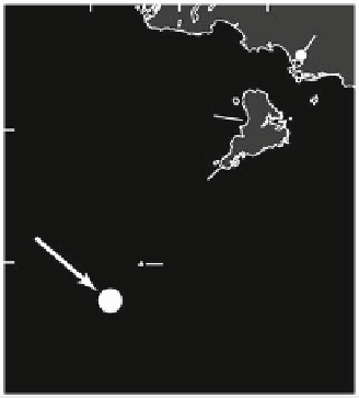
Fig. 9.11
Location map of Australia and New Zealand where physical and legendary evidence exists for tsunami
would have generated an earthquake with a surface wave
magnitude of 8.3. A tsunami 75 m high at the southern tip of
Stewart Island and 5 m high approaching the coast south of
Sydney, Australia is feasible. The lack of sediment that
normally settles over time from the ocean suggests that the
crater is less than 1000 years old (Abbott et al.
2003
). The
comet has been named Mahuika after the Maori God of fire.
Tektites found in sediments to the southeast indicate a tra-
jectory for this comet from the northwest, across the east
coast of Australia (Matzen et al.
2003
). If the recent age of the
event is correct, Aborigines in Australia and Maori in New
Zealand would have observed this comet's dying moments.
One of the more intriguing legends supporting a cos-
mogenic impact in the southwest Pacific is the New Zealand
Maori legend known as the Mystic Fires of Tamaatea or
Tamatea (Steel and Snow
1992
). The legend is prevalent in
the Southland and Otago regions of the South Island, cen-
tered on the town
appears to be evidence for an airburst that flatten trees
similar to the Tunguska event. The remains of fallen trees
are aligned radially away from the point of explosion out to
a distance of 40-80 km. Local Maori legends in the area tell
about the falling of the skies, raging winds, and mysterious
and massive firestorms from space. The Sun was screened
out, causing death and decay. Maori place names refer to a
Tunguska-like explosion although no volcanism exists in
the region (Tregear
1891
). Tapanui, itself, translates locally
as ''the big explosion''. One legend states that the Aparima
Plains west of Invercargill were flooded. The Maori also
attribute the demise of the Moas, as well as their culture, to
an extraterrestrial event. The extinction of the Moa is
remembered as Manu Whakatau, ''the bird felled by strange
fire''. One Maori song refers to the destruction of the Moa
when the horns of the Moon fell down from above. On the
North Island, the disappearance of the Moa is linked to the
coming of the man/god Tamaatea who set fire to the land by
of Tapanui (Fig.
9.11
b). Here there