Geoscience Reference
In-Depth Information
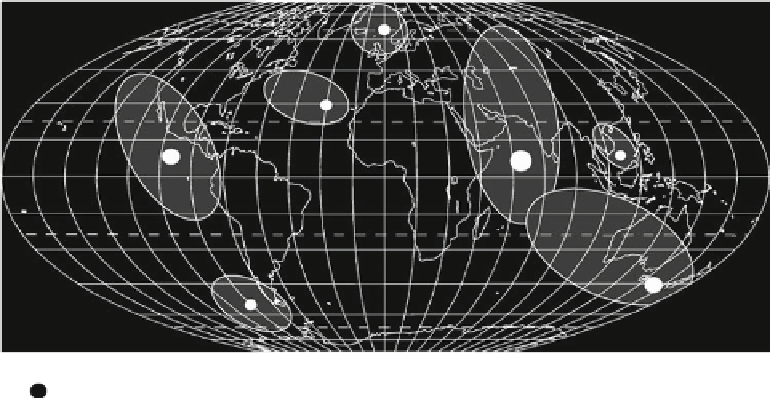
Fig. 9.9
Reconstruction of the
impact sites of fragments of the
Deluge Comet 8200 ± 200 years
ago based upon geological
evidence and legends. From
Kristan-Tollmann and Tollmann
(
1992
)
Site of impact
(proportional to size of comet fragment)
Area immediately affected
timing and the resulting consequences. Many of the legends
describe animistic images in the sky preceding the flood that
can be associated with the pre-perihelion and post-perihe-
lion stages of a near-Earth comet. The flood was associated
in many cases with torrential rainfall lasting between 4 and
10 days and a tsunami event. The two earliest written ver-
sions of this flood myth from Mesopotamia—the Gilgamesh
and Atrahasis epics written in the 2nd and early 3rd mil-
lennium BC—have the flood storm lasting approximately
7 days. Given historical rainfalls from tropical cyclones,
this yields 7.8 m of rainfall. The rainfall was ubiquitously
hot, and preceded by wind and overwhelming darkness.
Although a relatively small number of myths note that
survivors fled to the tops of high mountains such Mount
Ararat (Turkey) and Mount Parnassus (Greece), legends in
California, Brazil, Tierra del Fuego, Indonesia, and India
indicate flooding 15-100 km inland, and 150-300 m above
sea level. The seasonal and lunar data for legends are
remarkably consistent. Based upon these, archaeological
evidence and simulations using astronomical software pro-
grams, the comet struck in the middle of the Indian Ocean
on or about May 10, 2807 BC Masse (
2007
).
Subsequently, using clues from these myths, a large
impact crater—named the Burckle crater—was identified in
the Indian Ocean at 30.87S, 61.36E as being a possible
candidate for this event (Masse
2007
; Abbott et al.
2005
).
The crater is 29 km in diameter, lies at a depth of 4000 m
and is situated on the wall of a fracture zone south of the
Southwest Indian Ridge (Fig.
9.10
). It was found using
satellite altimetry and gravity interpretations of sea floor
bathymetry. Submarine impact craters form when an
impactor with a diameter that is at least 1/10 of the water
depth strikes the sea floor (Gusiakov et al.
2010
). After the
initial explosion, the impact water cavity and associated
sediment collapse inward, filling the interior of the crater.
The resulting crater rim is more subdued than those found on
land and has gullies eroded by water surging back into the
crater. All of these characteristics are present for the Burckle
crater. Burckle's location on a fracture zone wall implies that
its impact ejecta contains mantle rocks such as serpentinized
peridotites, oceanic sediment and oceanic basalt. There are
five cores within the theorized ejecta zone of the Burckle
crater containing mineral, rock and glass fragments; nearly
pure carbon impact spherules; and calcite rhombohedrons.
The latter are the most common type of impact ejecta, which
can preserved at the depths of a crater such as this.
The energy of the Burckle impact was 200,000-300,000
times that of the Krakatau eruption (Abbott et al.
2005
).
Using this analogue, tsunami run-ups were 10-100 m on
shorelines surrounding the Indian Ocean.
Such run-ups would have generated chevrons along sandy
coastlines. Kelletat and Scheffers (
2003
) predicted that the
tsunami source for chevrons in Western Australia lay at the
same latitude as the Burckle impact. A search of closer sites
found enormous chevron features in southern Madagascar
(Abbott et al.
2005
; Masse et al.
2007
; Gusiakov et al.
2010
).
These mega-tsunami chevrons are ubiquitous along the coast
of southern Madagascar, more so than on any other coastline
in the world. They extend, as six distinct complexes, west-
ward in a 375 km long chain from Taolagnaro (Fort Dau-
phin) to Itampolo Bay (Fig.
9.10
b). Each chevron represents
lateral transport of sediment onto the coast over many
kilometers: 20 km at Faux Cap, 30 km at Fenambosy, and
45 km at Ampalaza. In some cases, the chevrons overtopped
the front edge of the Karimbola Plateau escarpment situated
more than 125-150 m above the neighboring coastal plain.
Maximum run-ups of 200 m above present day sea level
occur at Faux Cap and of 190 m at Cap St Marie. The two
best delineated and preserved chevron dunes are those
associated with Ampalaza and Fenambosy Bays. The
Ampalaza chevron is 45 km in length and reaches 80 m
above present sea level (Fig.
9.10
c). It contains multiple sets