Geoscience Reference
In-Depth Information
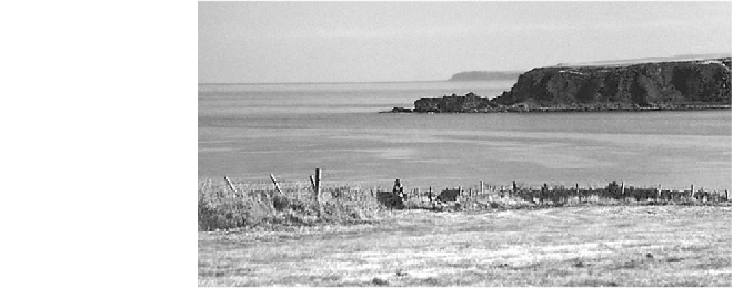
Fig. 7.15
The toothbrush-
shaped headland at Logie Head.
The larger depression has formed
either by catastrophic wave
breaking near the shoreline or by
concentrated high-velocity flow
Storegga slide, situated at the base of the Rockall Trough
(Øvrebø et al.
2005
). These slides are undated. However,
one of them may have failed in historical time and affected
the Bristol Channel and Severn Estuary on the west coast of
the United Kingdom.
Historic floods here are reasonably well documented;
however, the flood of the January 30, 1607 was catastrophic
(Bryant and Haslett
2007
). It flooded 518 km
2
along
570 km of coastline (Fig.
7.16
), killed up to 2,000 people
(Fig.
7.1
), and resulted in economic loss from which the
region never recovered. It was Britain's worst disaster on
land. The area affected extended from Barnstaple in Devon
and Carmenthen in Wales to the head of the Severn Estuary
at Gloucester (Morgan
1882
; Boon
1980
; Skellern et al.
2008
). Flooding was most severe around Burnham-on-Sea,
Kingston Seymour, and Newport. The greatest death toll
appears to be centered on Burnham-on-Sea. At Bridgwater,
10 km south of this town, 500 drowned and were buried in a
mass grave. Many local churches around Kingston Seymour
and Newport record the event with commemorative plaques
showing that flood levels were 7.74 and 7.14 m respectively
above mean sea level. In the former region, floodwaters
1.5 m deep persisted across the flat marshland for ten days.
Many of the lowlands in the upper reaches of the Channel
were protected by levees with sluice gates strategically
placed to drain water at low tide after heavy rains. It took
ten days for rescuers to get to the gates and open them to
release the impounded waters.
There are many historical documents reporting the event,
which showed many of the characteristics of recent cata-
strophic tsunami (Anon
1607
,
1762
; White
1607
; Bryant
and Haslett
2003
). The flood occurred on a clear day and
took residents by surprise:
…for about nine of the morning, the same being most fayrely
and brightly spred, many of the inhabitants of these countreys
prepared themselves to their affayres then they might see and
perceive afar off as it were in the element huge and mighty
hilles of water tombling over one another in such sort as if the
greatest mountains in the world had overwhelmed the lowe
villages or marshy grounds. Sometimes it dazzled many of the
spectators that they imagined it had bin some fogge or mist
coming with great swiftness towards them and with such a
smoke as if mountains were all on fire, and to the view of some
it seemed as if myriads of thousands of arrows had been shot
forth all at one time. (Mee
1951
).
The reference to dazzling, fiery mountains, and myriads of
arrows, is similar to accounts of tsunami on the Burin
Peninsula, Newfoundland in 1929 where the tsunami crest
was shining like car headlights, and in Papua New Guinea
in 1998 where the tsunami was frothing and sparkling. In
addition the wave approached at great speed:
…affirmed to have runne …. with a swiftness so incredible, as
that no gray-hounde could have escaped by running before
them. (Morgan
1882
).
Finally, a fully laden 60 tonne ship ready to set sail at
Appledore in north Devon was transported from the harbor
onto marshland by the wave, a situation that is unlikely if
storm conditions were prevailing at the time.
Geomorphic evidence for tsunami in the Channel can be
found in the form of transported and imbricated boulders;
bedrock sculpturing on coastal platforms and ramps; and, at
isolated locations, wholesale erosion of the coastal land-
scape (Bryant and Haslett
2007
). Features of bedrock
sculpturing are ephemeral, but telling. At Ifracombe, 30 cm
high flutes are cut into slate beds at a low 5 angle aligned
with the direction of tsunami approach (Fig.
7.17
). These
smaller flutes are superimposed upon sail-like structures
about 5 m high having the same orientation. The flutes give
the sails a cockscomb-like appearance similar to those in
erosion has cut through beds dipping 5 seaward producing