Geoscience Reference
In-Depth Information
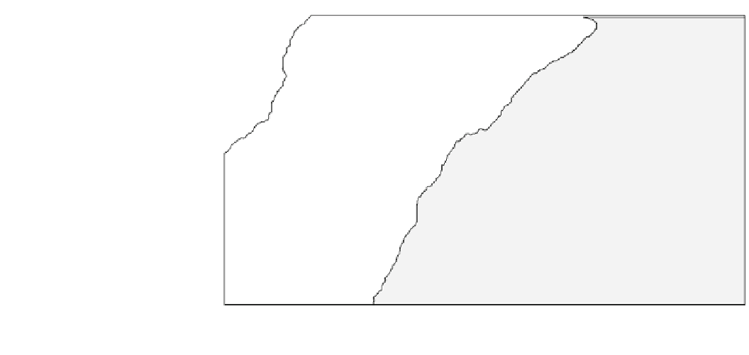
Fig. 7.9
The giant landslides of
the Canary Islands. Based on
Masson (
1996
), Carracedo et al.
(
1999
) and Masson et al. (
2006
).
Ages based on Masson et al.
(
2006
) and Boulesteix et al.
(
2013
)
-
2
4°
-22°
-20°
-18°
-16°
-14°
-12°
32°
Madeira
Abyssal
Plain
La Palma
30°
Canary
Island
debris
flow
Tenerife
>800
Lanzarote
>600
~160
~528
>900
540
~810
~15
28°
>175
Fuerteventura
Fuerteventura
La
Gomera
~160
>160
Gran
Canaria
El Hierro
Africa
26°
Ages are in
'000s of years
Debris flow
Giant landslide
one landslide has occurred somewhere in the Canary Islands
every 10,0000 years; however most events are irregular.
Most of the landslides are debris avalanches, with slumps
only occurring on El Hierro, which is the youngest island to
develop. El Hierro has undergone the most recent activity
(Masson
1996
). The youngest slide on the northwest corner
of El Hierro contains by far the largest mass of debris
identified as originating from the Canary Islands. It is
50-75 m thick and covers an area of 1,500 km
3
(Fig.
7.9
). It
appears linked to a single catastrophic failure involving
700-800 km
3
of material that occurred 13,000-17,000 years
ago when global sea levels were over 100 m lower than
present. Its headwall scarp is at least 8 km long and up to
900 m high. Closer to shore, the debris avalanche contains
individual blocks 1.2 km in diameter and 200 m high. Most
of the other debris flows have formed on the west side of the
islands with some having accreted through multiple events
(Carracedo et al.
1999
; Masson et al.
2006
). There are two
slides, one each on Tenerife and La Palma, which have
approximately the same age between 528,000 and
540,000 years at a time of rising sea-levels following a
global ice age (Boulesteix et al.
2013
). It is possible that a
large slide can trigger another on an adjacent island through
isostatic readjustment or a large tsunami. Seven turbidites,
ranging in volume from 5 to 125 km
3
and linked geo-
chemically to the islands, have been mapped on the abyssal
plain west of the Canary Islands up to 600 km away
(Masson et al.
1996
,
2006
). All are less than 650,000 years
old. The slides associated with these turbidites reach vol-
umes of 1,000 m
3
and were most likely induced by over
steepening of the volcanoes through successive eruptions or
by the emplacement of vertical dykes.
Tsunami deposits have now been identified in the Canary
Islands and linked by their juxtaposition to landslides on
Tenerife (Masson
1996
; Masson et al.
1996
). None has been
dated, however, so they cannot be associated with any
specific debris avalanche. One deposit has been mapped on
the Jandia Peninsula on the south side of Fuerteventura
Island (Carracedo and Day
1997
). The deposit is unstratified
and consists of well-rounded boulders and pebbles, marine
molluscs, and angular pieces of basalt. It lies at an elevation
of 35-75 m above present sea level up to 1 km inland.
Fuerteventura Island is tectonically stable, so the elevation
of the deposit cannot be attributed to tectonic uplift. A
similar deposit, consisting of two upwards-coarsening beds
of beach boulders and shell, has also been discovered up to
90 m above present sea level at Agaete, on the northwest
coast of Gran Canaria. A deposit containing shell also exists
more than 200 m above sea level on La Palma.
7.5.3
The Storegga Slide of 7,950 BP
In 1812, Sir James Hall postulated that a range of bedrock
sculpturing features that included hairpin erosion marks
several meters in length and the crag-and-tail hills that make
up the city of Edinburgh were shaped by a tsunami similar
to the one that had destroyed Lisbon in 1755 (Hall
1812
). It
was one of the first attempts in geology to explain the
evolution of a landscape by invoking a single physical
process. Hall of course was wrong. He knew nothing about
continental glaciation that was subsequently used to explain
the landforms. He was also unfortunate in picking the
wrong landforms as examples. Had he examined the raised