Geoscience Reference
In-Depth Information
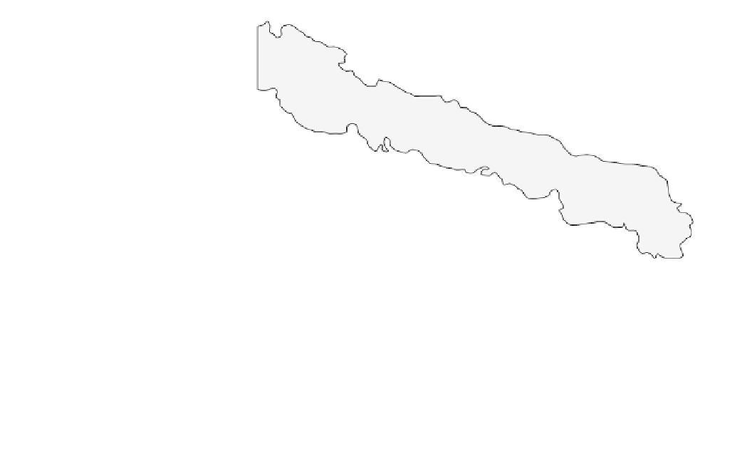
Fig. 7.8
Location of submarine
slumps and debris flows on the
Hawaiian Ridge. Based on Moore
et al. (
1989
), and Moore et al.
(
1994a
,
b
)
-175°
-170°
-165°
-160°
-155°
Volcanoes
Debris apron
30°
Maro Reef
Debris slides
Gardner Pinnacles
Necker Island
25°
Oahu
Hawaii
Midway Island
2000 m
isobath
Nuuanu slide
20°
Molokai
Maui
Kauai
Oahu
Lanai
Slide
Exposed
Island
Alika 1
slide
Alika 2
slide
0
50
100 150 km
Hawaii
western side of Hawaii Island totals 1,500-2,000 km
3
—
much of it originating underwater down to 4,500 m depths.
The second slide traveled more than 50 km from the coast
in a northwesterly direction towards the small island of
Lanai. Uncharacteristically steep slopes, reaching 2,000 m
above sea level on the southwest side of Mauna Loa, appear
to represent the headwall of the slides. Failure occurred in
the unbuttressed flanks of Mauna Loa and Hualalai volca-
noes along rift zones infilled with dykes. Sedimentation
rates on these slide deposits suggest that they are only a few
hundred thousand years old.
This age and the potential of the slides for tsunami
generation link them to anomalously high gravel and
boulder deposits of a similar age on nearby islands to the
northwest (Moore and Moore
1988
). These deposits reach
elevations above sea level of 61 m on the southeastern tip of
Oahu, 65 m on the south coast of Molokai, 73 m on the
west coast of Maui, 79 m on the northwest corner of
Hawaii, and 326 m on the south coast of Lanai. On Lanai,
catastrophic wave run-up may have deposited discontinuous
dune-like boulder ridges, known as the Hulopoe Gravel, up
gullies and on interfluves. The waves were also erosive
removing a 2 m depth of weathered soil and basalt in a
2 km wide strip parallel to the coast. The highest elevation
of stripping is 365 m above sea level on Lanai and 240 m
on the west side of Kahoolawe. On the northeast sides of
both islands, the height of stripping only reached 100 m
several hundred kilometers per hour have been inferred
(Moore et al.
1994b
). If the Hawaiian debris avalanches
obtained similar velocities, then they were major agents for
tsunami generation in the Pacific. Unlike slumps, debris
avalanches are thinner, having thicknesses of 0.05-2.0 m;
however, they may travel as far as 230 km on slopes as little
as 3. The largest submarine avalanche is the Nuuanu debris
avalanche on the northern side of Oahu Island (Fig.
7.8
). It
is 230 km long, with a maximum thickness of 2 km at its
source. It covers an area of 23,000 km
2
and has a volume of
5,000 km
3
(Table
7.1
) (Masson et al.
1996
). This represents
one of the largest debris avalanches on Earth. It possibly
occurred 200,000 years ago and would have sent a wave
20 m high crashing into the United States west coast (Ward
2001
). Debris avalanches are characterized by hummocky
terrain at their distal end with some of the hummocks
consisting of blocks of volcanic rock measuring 1-10 km in
width (Masson et al.
1996
). The largest individual block
identified so far occurs in the Nuuanu deposit and measures
30 9 17 9 1.5 km
3
.
The Alika debris avalanches on the western side of the
main island of Hawaii are two of the youngest events in the
island chain (Fig.
7.8
). The older avalanche, Alika 1, covers
an area of 2,300 km
2
; the younger, Alika 2, is slightly
smaller, covering an area of 1,700 km
2
(Lipman et al.
1988
). Together, both failures incorporate 600 km
3
of
material, although the volume of material missing from the