Geoscience Reference
In-Depth Information
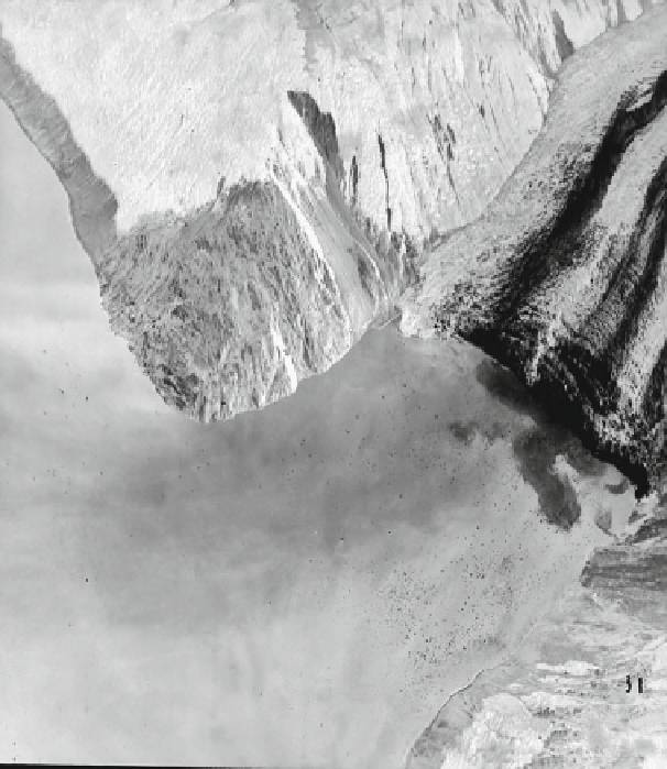
524-m run-up limit
Lituya
Glacier
Slide scar
On the opposite spur to the glacier, splash from the impact
swept upslope to a height of 524 m above sea level, or more
than three times the water depth of Gilbert Inlet. This splash
has been mistaken for a giant wave of solid water; however it
probably entrained a considerable volume or air. The rockfall,
in combination with ground uplift at the head of the bay,
generated a solitary wave 30 m high that swept down the bay
to the ocean at a speed of 155-210 km hr
-1
. Mathematical
modeling using incompressible, shallow-water long-wave
equations described in
Chap. 2
supports these figures. Run-up
from the wave swamped an area of 10.4 km
2
on either side of
the bay and penetrated as much as 1 km inland (Fig.
7.6
). Soil
and glacial debris were swept away, exposing clean bedrock;
however, little erosion of bedrock took place despite theo-
retical water velocities as high as 30 m s
-1
.
120-260 km wide swathe over a distance of 245 km along
the slopes of the continental shelf (Piper et al.
1999
). At
least 7,200 km
2
of sea floor failed. The slides occurred at
two scales, as small rotational slumps 2-5 m thick and as
larger ones 5-30 m thick. These coalesced over several
hours into debris flows and then a turbidity current. The
event is noteworthy because it was the first submarine
debris flow detected and published. The turbidity current
was hundreds of meters thick and swept downslope over the
next 11 h, cutting 12 telephone cables between Europe and
North America (Heezen and Ewing
1952
; Canals et al.
2004
). Based upon the time when each cable was broken,
the turbidity current obtained a maximum velocity of
15-20 m s
-1
. At its terminus, the resulting turbidite cov-
ered an area of 160,000 km
2
of seabed with 185 km
3
of
sediment, to a maximum depth of 3 m (Piper et al.
1999
).
Sediment was deposited more than 400 km from the site of
the slump in water depths of more than 2,500 m. This is one
of the biggest turbidity currents yet identified either his-
torically or geologically.
Little publicity has been given to the tsunami that fol-
lowed the 1929 event (Whelan
1994
). Two and a half hours
after the earthquake, a 3 m high wave surged into the Burin
Peninsula on the south coast of Newfoundland, directly
opposite the headwall of the slide (Fig.
7.7
).Thewavewas
7.4.2
Grand Banks Tsunami, November 18,
1929
The Grand Banks Tsunami was produced by a submarine
landslide or slump triggered at 5:02 PM by an earthquake
that had a surface wave magnitude, M
s
, of 7.2. The earth-
quake had an epicenter in about 2,000 m depth of water
(Fig.
7.7
).
Numerous
submarine
slides
occurred
in
a