Geoscience Reference
In-Depth Information
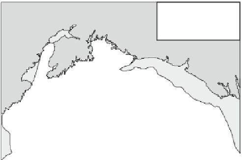
Fig. 6.9
Earthquake and
tsunami characteristics of the
Great Alaskan Earthquake of
March 27, 1964. Based on Van
Dorn (
1965
), Pararas-Carayannis
(
1998b
), and Johnson (
1999
):
a Location of seismic activity
since 1938. b Gulf of Alaska land
deformation caused by the
earthquake and theorized open-
Pacific tsunami wave front.
c Detail of Prince William Sound
-180°
-160°
-140°
65°
(a)
Anchorage
Valdez
60°
Kodiak
Island
Bering Sea
1964
M
w
=
9.2
55°
a n
1938
M
w
=
8.2
1946
M
w
=
7.4
50°
Gulf of Alaska
1965
1986
M
w
=
7.7
1957
M
w
=
9.1
M
w
= 8.7
45°
1964 epicentre
(b)
Uplift
Subsidence
Seismic activity
since 1938
Kenai
Peninsula
Cape Yakataga
Gulf of
Alaska
s
Trinity Islands
0
100
200 km
(c)
Valdez
4
Cape Yakataga
2
Whittier
0
-2
-4
Chenega
Seward
1
2
3
4
5
6
Prince William
Sound
Hours after earthquake
Montague Is.
Latouche Is.
1946, and March 9, 1957 (Table
1.3
). The most recent
sequence of seismic activity began in 1938 with large
earthquakes in 1938, 1946, 1957, 1964, and 1965 (Soko-
lowski
1999
). The last three events are amongst the 10
largest earthquakes of the 20th century. The southwards
movement of Alaska over the Pacific Plate at a shallow
angle of 20 has generated these earthquakes, forming a
subduction zone known as the Aleutian-Alaska Megathrust
Zone. Shallow dip favors large trans-Pacific tsunami. The
epicenter of the 1964 earthquake was located in northern
Prince William Sound at 61.1 N, 147.5 W (Fig.
6.9
a). The
earthquake had a focal depth of 23 km and surface and
moment magnitudes of 8.4 and 9.2 respectively—the largest
ever measured in North America. The earthquake rang the
Earth like a bell and set up seiching in the Great Lakes of
North America and in Texas 5,000 km away. Water levels
in wells oscillated in South Africa on the other side of the
globe. The ground motion was so severe around the epi-
center that the tops of trees were snapped off. More sig-
nificant, ground displacement occurred along 800 km of the
Danali Fault system parallel to the Alaskan coastline. Fig-
ure
6.9
b shows that the dislocations followed a dipole pat-
tern of positive and negative displacements on either side of
a zero line running through the east coast of Kodiak Island,
northeast to the western side of Prince William Sound
(Johnson
1999
). Maximum subsidence of 3 m occurred
west of this line, while as much as 11 m of uplift occurred
to
the
east.
At
some
locations,
individual
fault
scarps