Geoscience Reference
In-Depth Information
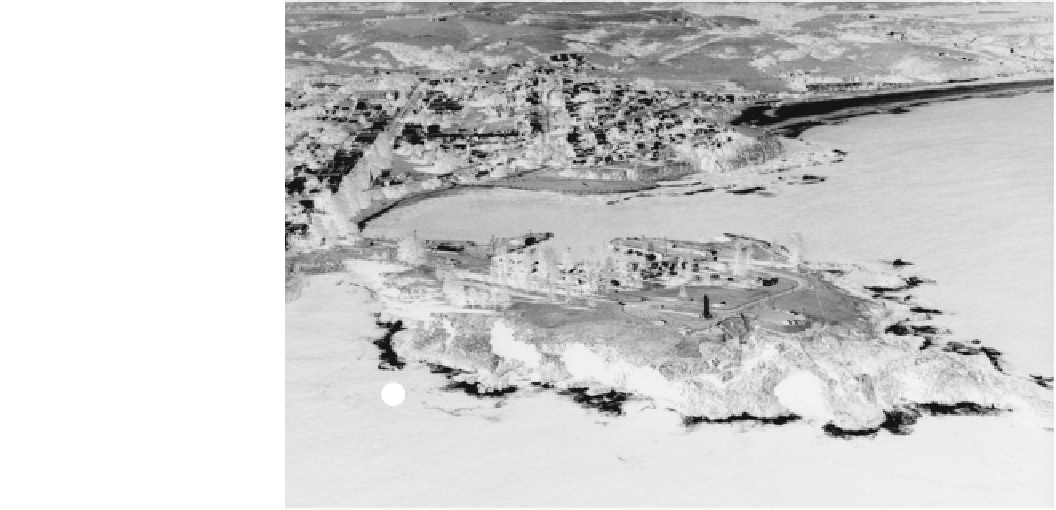
Fig. 4.9
Kiama Headland lying
40 km south of Flagstaff Point
(Fig.
4.8
). A paleo-tsunami also
approached from the southeast
(white arrows) and swept over
the headland. Here caves have
been bored into columnar basalts.
Main features (white lines) are as
follows: a large muschelbrüche-
like feature, b incipient caves,
c cave leading to blowhole,
d hummocky topography on
raised platform, e smear deposit
over headland, and f sheared cliff
face and planed platform. A sand
sheet was again deposited across
the bay (g)
g
f
e
d
a
b
c
more resistant to erosion. Vortices eroded into the headland
along major joints forming broad caves. At one location, a
vortex penetrated 50-80 m along a joint, creating a cave
that blew out at its landward end to form the Kiama
Blowhole. Where the headland was lower in elevation,
vortices began to scour out large muschelbrüche about 50 m
in length. The tip of the headland, instead of being eroded
into a reef, was heavily scoured into hummocky bedrock
topography to form a surface 8-10 m above sea level.
Boulders were scattered across this surface. The wave also
planed the top off the headland and deposited a 5-10 cm
thick smear deposit that thickens downflow. The wave then
crossed a small embayment in the lee of the headland,
shearing the end off a cliff. Finally, the wave deposited
quartz sand inland about a kilometer to the northwest.
can be found at elevations of 8-10 m above sea level. One of
the largest boulders is found at Cow Bay. It has a volume of
106 m
3
and weighs 286 tonnes. At Oak Beach, imbricated
boulders weighing up to 156 tonnes and measuring over 8 m
in length can be found in piles (Fig.
4.10
). Using Eqs. (
3.3
)
and (
4.2
), it can be shown that tsunami rather than storm
waves are the most feasible mechanism generating the flow
velocities required to transport many of these boulders.
These comparisons are presented in Table
4.2
. All of the
imbricated boulders can be transported by tsunami 5.0-11.
2 m in height. The highest waves are required to move the
boulders found at Cow Bay. The smallest storm wave must
be 20 m high to move these boulders. This is virtually
impossible because such a wave would break before reach-
ing the coastline, even when superimposed on surges that
can be up to 7 m high. The tsunami waves can generate
theoretical flow velocities ranging from 3.7-10.4 m s
-1
,
with a mean value of 5.8 m s
-1
. The highest of these
velocities is more than sufficient to produce cavitation and
sculpture bedrock. Indeed, many of the bedrock surfaces
near the boulder piles evince bedrock-sculpturing signatures.
For example, the boulders found at Oak Beach are emplaced
on an undulatory, smooth surface characteristic of erosion by
transverse roller vortices (Fig.
4.10
). S-forms are also evi-
dent on this bedrock surface. The northern headland of Oak
Beach has also been dissected into a toothbrush shape that is
covered with flutes, sinuous grooves, and cavitation drill
holes (Fig.
4.11
).
The tsunami in the Cairns region have originated in the
Coral Sea outside the Great Barrier Reef. It appears that
4.5.2
Cairns Coast, Northeast Queensland
The signatures of tsunami are not restricted in Australia to
the southeast coast. They also appear inside the Great Barrier
Reef between Cairns and Cooktown along the northern
Queensland coast (Fig.
3.3
b). This, at first, would appear to
be unlikely. Even if tsunami have occurred in this part of the
Coral Sea, the Great Barrier Reef should have protected the
mainland coast. Evidence now suggests that tsunami have
indeed reached the mainland coast with enough force, not
only to transport boulders, but also to begin sculpturing
bedrock (Nott
1997
; Bryant and Nott
2001
). For example, at
many locations, boulders weighing over a hundred tonnes