Geoscience Reference
In-Depth Information
55˚N
45˚N
35˚N
25˚N
15˚N
140˚E
160˚E
180˚
160˚W
140˚W
120˚W
now Figure 4-3
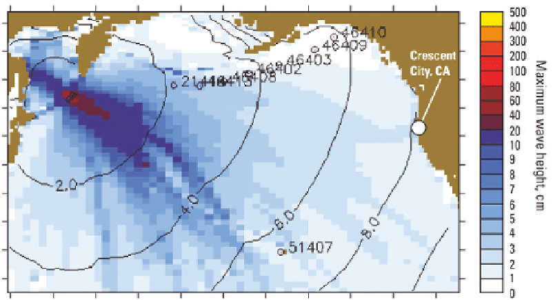
FIGURE 4.3
North Paciic Ocean, showing predicted maximum wave heights (indicated by color) and
arrival times (contour lines labeled with numbers representing hours after the triggering earthquake) of
tsunami waves generated by a magnitude 8.3 earthquake near the Kuril Islands on November 15, 2006.
The predicted wave heights illustrate the phenomenon of “tsunami beaming”—the tendency of tsunami
waves in the open ocean to be highest along azimuths approximately perpendicular to the subduction
zone where the triggering earthquake occurred. Note the minor beam aimed at Crescent City, California,
where the boat harbor was damaged, largely by secondary tsunami waves. SOURCE: Geist et al., 2007; with
permission from Vasily Titov, NOAA/PMEL.
term tide stations, and the National Weather Service (NWS) utilized the data to support the
national tsunami warning system. However, following the devastating 2004 Indian Ocean
tsunami, and with the support authorized in P.L. 109-424, CO-OPS began a system-wide up-
grade of its instrumentation. This upgrade increased the rate of data collection to 15-second
and 1-minute sampling (National Tsunami Hazard Mitigation Program, 2008) and increased
the rate of transmission (to every 6 minutes) at its coastal National Water Level Observation
Network (NWLON; http://tidesandcurrents.noaa.gov/nwlon.html) stations. The increased data
sampling and transmission rates advance the objectives of tsunami detection and warning, as
well as to provide critical inundation model input. In addition to upgrading equipment at 33
existing long-term NWLON stations, CO-OPS collaborated with the TWCs and the Paciic Marine
Environmental Laboratory (PMEL) to establish 16 new tide stations at high-priority locations
in Alaska, the Paciic Islands, the U.S. West Coast, and the Caribbean, increasing the geographic
coverage of water level observations in tsunami-vulnerable locations. This initiative was com-
pleted in 2007 (National Tsunami Hazard Mitigation Program, 2008; http://tidesandcurrents.
noaa.gov/1mindata.shtml).