Geology Reference
In-Depth Information
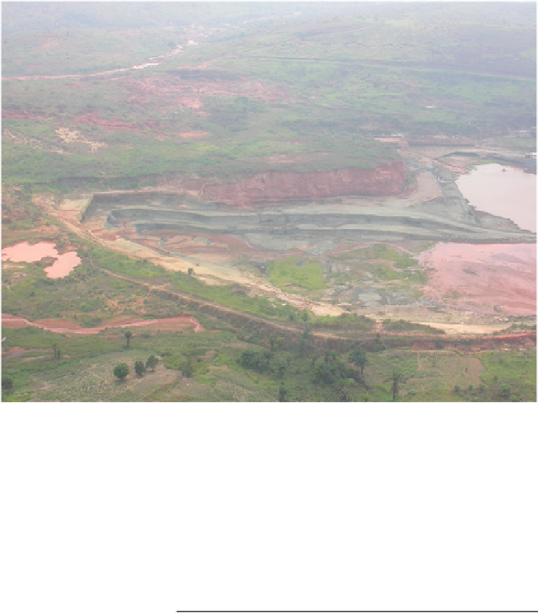
Fig. 17.8
Photograph of
Tshibwe kimberlite pipe, viewing
northwest (photo John Ward)
are here referred to as the Southern Group of the Mbuji Mayi
kimberlite field encompassing Tshibwe, Tshinyama,
Kakongo, Tshambila, Ndaye
The diamond potential of the hard
kimberlite
of the pipe was subsequently tested and mined from 670 m to
500 m by MIBA (1981-2000), Sengamines (Senga-Senga
SARL, 2000-2005, with MIBA as minority shareholder) and
more recently, Societ´ Anhui-Congo d
'
Investissement
Minier Sprl, or SACIM (2013-present). The Sengamines
operations produced 2.03 Mcts at a run-of-mine grade of
0.8 cts/m
3
and revenue of US$ 16/ct (Michaelides
2006
).
“
blue ground
”
and Tshinkasa
pipes
(Fig.
17.5
).
The Tshibwe kimberlite is located within a broadly
east-west orientated valley surrounded by low hills. The
Tshibua stream passes across the kimberlite but the flow
has been diverted and controlled in order to prevent flooding
of the open pit. It joins the Katsha tributary which flows to
the southeast to the Tshimanga mining area and there joins
the Mbujimayi River (Fig.
17.5
). Dredging of gravels down-
stream of Tshibwe pipe has proven lucrative with the 100 m
wide by 20 m deep Senga-Senga pothole in the Mbujimayi
River
17.5
Bas-Congo Kimpangu Kimberlite Field
Several kimberlite dykes were found south of Kinshasa close
to the border with Angola, intruded into Neoproterozoic
sediments of the West Congolian Group (Fig.
17.1
). The
dykes are up to 3 m wide and trend north-northeast. The
kimberlites were discovered by De Beers in 1974 during a
reconnaissance sampling program but no diamonds were
found associated with these occurrences and the mineral
chemistry suggests an off-craton setting (de Wit
2006
).
One of the kimberlites is referred to as Kimpangu and was
explored by SouthernEra (Evans
2004
). More recently,
Kapapa Eleazard (
2011
) mentions the presence of a kimber-
lite pipe at Kimpangu for which little is known—
(Fig.
17.4
) delivering five million carats
from
100,000 m
3
of ore.
Estimates of the extent of the kimberlite sub-outcrop
range from 40 to 60 ha, with an E-W axis of 1400 m and
an N-S axis of 600 m. In cross-section, the pipe has a flared
(albeit asymmetric) champagne-glass shape, with a narrow
neck some 200 m in diameter (Fig.
17.9
). The facies of the
pipe are dominated by volcaniclastic kimberlite, including
sandstone-rich, monolithic and heterolithic breccia types
(RVK), as well as the more competent, green-grey, massive
volcaniclastic (PK) and transitional kimberlite types.
The eluviated and weathered surface horizon (
'
On signale
qu'une pipe kimberlitique existe ` Kimpangu mais il est peu
´tudi´
“
yellow
ground
) over Tshibwe pipe was mined by MIBA between
1978 and 1980, with reported grades in excess of 2 cts/m
3
.
”
(A kimberlite pipe is reported at Kimpangu but it has
been little studied).
'

Search WWH ::

Custom Search