Geology Reference
In-Depth Information
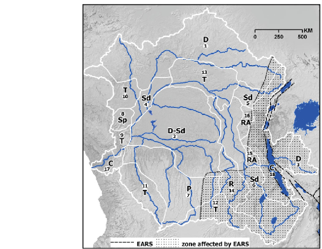
Fig. 15.7
The EARS (
black
dashed lines
) and its affect on the
CB drainage patterns. The
stippling indicates the regions of
the CB that been affected by
seismic activity linked to the
EARS. Drainages close to the rift
are most affected by seismic
activity, which has a calculated
extent of up to 450 km west of the
EARS. At distances greater than
450 km, the probability of a
seismic event exceeding a peak
ground acceleration (PGA) of
0.05 g is less than 10 % in 50
years (Mavonga and Durrheim
2009
). This relative higher
probability and greater PGA of
seismic events closer to the rift
could account for the occurrence
of Sd5 (Lindi), RA15
(Lulwango), RA16 (Ulindi), Sd6
(Luvua), R14 (Bushimay) and
T12 (Lufupa) networks. The
limited affects on D3 (Upper
Malagarasi) may be related to its
proximity to a cratonic region.
Interestingly the lower region of
the Malagarasi river has become
contorted (C18)
southern reaches have a dominant south-west orientation,
suggesting some degree of structural control in the region.
A large portion of this zone corresponds to the Precambrian
basement (Deffontaines and Chorowicz
1991
); with evi-
dence of recent tectonic activity along Lake Mweru and a
wide alluvial plain upstream of the lake, near Kasenga (Tack
et al.
2003
). This tectonic activity, associated with the West-
ern Branch of the EARS, is the probable explanation of the
sub-dendritic pattern in this region (Fig.
15.7
). The similar
morphologies of the Ufipa Plateau and Rukwa basins (north
of the Chambeshi headwaters, in the Tanganyika-Rukwa-
Malawi rift zone) to the Kundelungu Plateau and Lake
Mweru provide further evidence of tectonic control of the
drainage (Fig.
15.5
). While the Rukwa Plateau is generally
tilted towards Lake Tanganyika, several of its rivers drain
into Lake Rukwa, possibly reflecting a combination of ante-
cedence and tectonic control of these rivers (Delvaux et al.
2012
). Additionally there appears to be no river offsets
across the scarps (Delvaux et al.
2012
). The importance of
tectonic events in the region is illustrated by 1910 earth-
quake in the region that is estimated to have been 7.4 in
magnitude (Delvaux et al.
2012
). Similarly, localised
faulting and uplift appears to have morphed the dendritic
network into a sub-dendritic pattern. In summary, much of
the sub-dendritic pattern represents the interplay between
the inherent structural controls of the Precambrian basement
on the one hand, and extensional movements of Neogene to
late Holocene age, as is suggested for the Upemba Trough
(Fig.
15.5
; Deffontaines and Chorowicz
1991
). This may be
further enhanced by rift associated uplift that promoted
erosion and incision of the pre-rift sediment and/or base-
ment, with this rift flank induced river system draining into
the basins (i.e. Mweru) in structurally low-lying regions
between fault segments.
15.3.3 Parallel
Within the CB, two areas exhibit parallel type drainages: the
parallel drainage of the southern plateau region of the basin,
as seen in the Luangwe System and the sub-parallel drainage
Search WWH ::

Custom Search