Geology Reference
In-Depth Information
Congo Basin
paleo-topography
a
marine incursion
elevation
(m)
b
400
300
40 m
20 m
70 m
150 m
330 m
230
400 m
280
120 m
230
220
460 m
-20 m
370 m
200
80 m
120
260
120 m
120
200 m
80
240 m
100
0
180
60
160
0
Sea-level
-40
130
0
analcime-rich
carbonate-rich
Tidal /
Aeolian
Glacio-lacustrine
Fluvial
Fluvio-lacustrine
Terrestrial
GUADA
LUPIAN
LOPIN
GIAN
PALEO
CENE
OLIGO
CENE
MISSISSIPIAN
CARBONIFEROUS
PENNSYLVANIAN
CIZURALIAN
LOW.
MIDDLE
UPPER
LOWER
MIDDLE
UPPER
LOWER
UPPER
EOCENE
MIOCENE
PERMIAN
TRIASSIC
JURASSIC
CRETACEOUS
PALEOGENE
NEOGENE
350
300
250
200
150
100
50
0
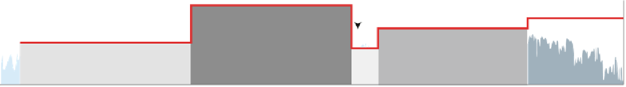
Fig. 11.4
Stratigraphic records (center section) and paleo-topographic model of the CB (
thick
red line
). The paleo-elevations (values in
red
,
top
section) are estimated from sedimentological
data and are adjusted to the long-term sea level curves of Haq et al. (
1987
) and Haq and Schutter
(
2008
). When corrected to the eustatic sea level maximum for the Late Jurassic marine
transgression in east-central Africa (ca. 160 m above present-day sea level), the Triassic and
Cretaceous paleo-topographic highs correspond to two peneplains (
a
and
b
) traced across the
CB by Stankiewicz and de Wit (
2006
)


Search WWH ::

Custom Search