Geology Reference
In-Depth Information
Mbandaka (log)
Gilson (log)
Dekese (core)
Samba (core)
Litho-
unit
Grain-size
% clay and silts
Base-level
Litho-
unit
Grain-size
% clay and silts
Base-level
Litho-
unit
Grain-size
% clay and silts
Base-level
Litho-
unit
Grain-size
% clay and silts
Base-level
Rise
Fall
Rise
Fall
Rise
Fall
Rise
Fall
C
S
fS mS cS Gr P
C
SfSmScS Gr P
C
S
fS mS cS Gr P
C
S
fS mS cS Gr P
0 m
0 m
0 m
0 m
D1
M1
95%
S1
5%
85%
G1
S2
25%
D2
Fluvial-
lacustrine
Lacustrine
R
10%
35%
85%
D3
40%
S3
M2
G2
500 m
500 m
500 m
500 m
5%
D4
Aeolian
50%
G3
D5
85%
MFS
75%
M3
100%
S4
D6
D7
M4
U3
5%
30%
G4
Tidal
20%
35%
G5
1000 m
1000 m
1000 m
1000 m
S5
90%
20%
Fluvial
(aeolian?)
Fluvial
(aeolian?)
M5
D8
10%
G6
R
1500 m
1500 m
1500 m
1500 m
30%
S6
D9
Sea /
Lake
Delta River
Soil /
Dunes
20%
D10
M6
- 1856 m
MFS
2000 m
2000 m
- 2038 m
G7
80%
Sea /
Lake
Delta River
Soil /
Dunes
T
20%
M7
2500 m
2500 m
Phanerozoic sequences:
U2
Glacial-
lacustrine
R
40%
Kalahari (Cenozoic)
Loia/Bokungu (middle Cretaceous)
Stanleyville/Dekese (Upper Jurassic to Lower Cretaceous)
Haute Lueki (Triassic)
G8
MFS
35%
30%
3000 m
3000 m
M8
G9
Sea /
Lake
Delta River
Soil /
Dunes
G10
T
Lukuga Group (Carboniferous to Upper Permian)
3500 m
3500 m
Inkisi Group (upper Neoproterozoic to lower Paleozoic)
20%
M9
G11
U1
4000 m
4000 m
Sea /
Lake
Delta River
Soil /
Dunes
M10
- 4343 m
4500 m
G12
- 4645 m
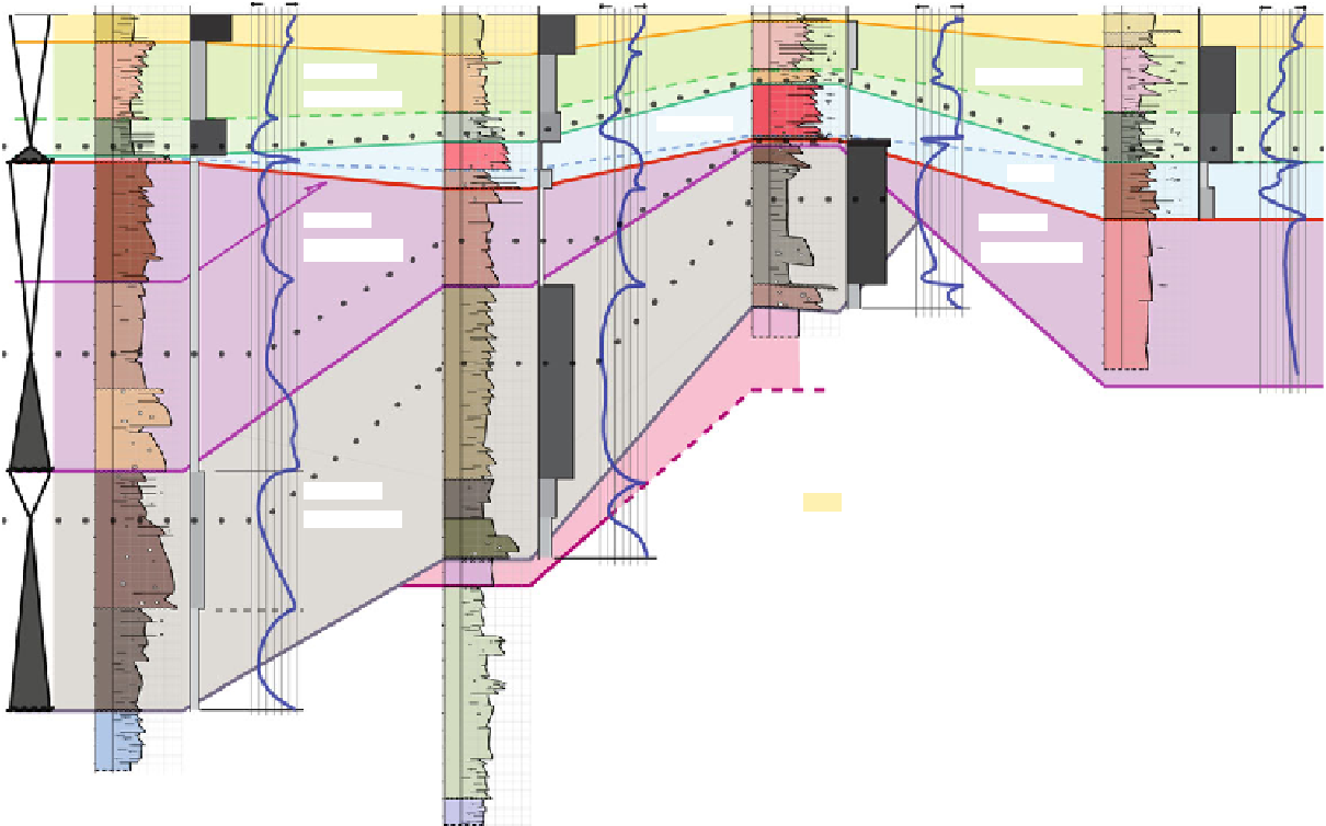
Fig. 11.3
Sequence stratigraphic correlations (
T
Transgression,
R
Regression,
MFS
Maximum flooding surface) and paleoenvironmental data of the four deep borehole-sections in the center of
the CB (Fig.
11.1
for locations). U1, U2 and U3 mark major unconformities determined from analysis of seismic (Linol
2013
; see Chap.
7
, this Topic)


Search WWH ::

Custom Search