Geology Reference
In-Depth Information
a
Samba
Kalahari Group
Dekese
Gilson
Mbandaka
Magkadigkadi
Pan
Tsodilo
Okavango
Delta
Etosha
Pan
carp
m
Congo
Fan
Orange Basin
KP
b
CB
Kwango
nick-point
EARS
extension
J-K sequences
Kalahari Group
Cape
Fold
Belt
N
S
Oubanguides
Belt
Lufilian Arc
Tsodilo
Drakensberg Basalts
Samba
Dekese
1
0
sea
Karoo Supergroup
Cape Supergroup
Lindian Supergroup
Central African Shield
Kalahari Shield
-5 km
0
5000 km
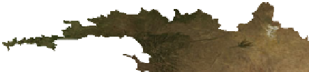
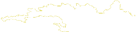
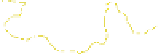
Fig. 10.1
(
a
) Digital elevation model of sub-Saharan Africa and (
b
)
N-S cross-section of the CB and KP, highlighting the vast extension of
Cenozoic sediments and duricrusts of the Kalahari Group (in
yellow
),
and with location of studied boreholes. Note that the transition between
the KP and CB is not related to the boundary between the Kalahari and
Central African Shields
are unconsolidated, there is relatively limited data available
from drill-cores (Haddon
2000
; Miller
2008
).
Here, we present new sedimentological and stratigraphic
data from drilling into the Kalahari Group on top of the KP,
in the Ngamiland region of northwest Botswana, and from
field investigations in the Kwango Valley of the southwest
CB, flanking the transition to the KP in the southern Demo-
cratic Republic of Congo (DRC). On the basis of well/core
and seismic data, we also extend this Kalahari sequence to
the center of the CB (Fig.
10.2
). Here, very little of the
Kalahari duricrusts cover is preserved, leaving a denuded
landscape (
'
Bad-Lands
'
) of Cretaceous red-beds sometimes
covered by residual blocks and large boulders of silcrete and
calcrete that suggest relatively recent collapse of the
Kalahari duricrusts and accelerated erosion across the CB
of its underlying poorly consolidated red-beds. Because the
off-shore sedimentation history of the Congo Fan along the
Atlantic margin reveals a sudden episode of
sedimentation in the Oligocene (e.g. Anka and S´ranne
2004
), we propose a new model of rapid disintegration of
the Kalahari duricrusts carapace and preferential erosion
(
) of the soft underlying red-beds across the
CB, driven by increased fluvial activity in response to global
cooling in the mid- to late Cenozoic (e.g. Zachos et al.
2001
).
'
flushing out
'
10.2
The Kalahari Group
The Kalahari Group covers most of southern and central
Africa (albeit poorly exposed), extending continuously
from the Orange River in South Africa, through Namibia,
Botswana, western Zimbabwe, Zambia, Angola, to the
Congo River in DRC and the Republic of Congo, covering
some 2.7 million km
2
(Figs.
10.1a
and
10.2
).
A thickness map of the Kalahari Group in southern
Africa, compiled mainly from borehole data of water wells


Search WWH ::

Custom Search