Agriculture Reference
In-Depth Information
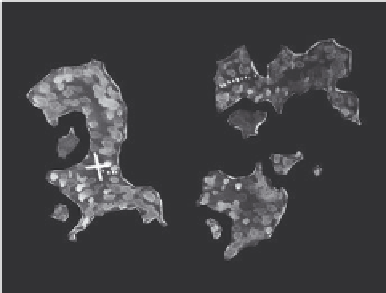
The three treasure maps shown in
Figures 6.5-A through 6.5-C were originally
drawn by hand and, like the map in Fig-
ure 6.4, were created with the purpose of
providing directions to a desired location
(the X, as in X marks the spot where trea-
sure was buried). The person looking for
the treasure would not be able to succeed
with only the information included in Map
A. Map A does not give any indication in
what hemisphere of the earth the islands
are located, just their shapes and relation to
north. Map B is significantly more helpful
in that it includes latitude and longitude.
Now the traveler knows in which part of
the earth's surface to begin to search for
the treasure. Map C includes a scale so that
horizontal distances can be determined.
The larger island where the treasure is bur-
ied shows contour lines. The elevation of
the contour lines, while not shown, would
provide the traveler with a fair idea of the
topography and landform, allowing him
or her to set out in the right direction to
the top of the hill at the southern end of
the island. Presumably by the probing of
a sword and a few test holes, the treasure
would be found. Minus the horizontal con-
trol provided by longitude and latitude,
mileage scale, and topographic contours,
finding the treasure with Map A would be
impossible unless, as in Map C, the per-
son drawing the map included additional
graphic clues such as contours and graph-
ics or provided a written description of the
physical features where the “X” is shown.
0 20 40 60 80
Miles
Figures 6.5-a-6.5-C
A series of treasure maps with
increasing degrees of useful information and clarity