Agriculture Reference
In-Depth Information
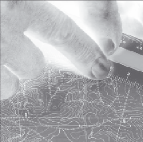
For an example of how to cal-
culate the average percent of slope
of a given area, refer to Figure 3.7,
taken from a portion of a USGS topo-
graphic quad map. The scale of the
topographic map in the example is 1
inch equals 2000 feet. See Chapter 5
to learn how to identify the scale of
a USGS topographic map. Using a 20
scale of an engineer's scale, the “0”
tick mark on the scale is shown as A.
The A tick mark is positioned on the
350-foot contour line. The B tick mark
on the engineer's scale falls on the
300-foot contour line. The B tick mark
is located on the 2500-foot mark of
the engineer's scale. To calculate the
slope between the 300 and 350 con-
tour lines, use the formula S = V/H, where S or percent of slope is not
known, V is the vertical distance between the 350' and 300' contours (50
feet), and the horizontal distance measured with the engineer's scale is
1500 feet. The calculation of slope is made as follows:
B
A
1” = 2,000'
Figure 3.7
USGS topographic map with engineer's scale used to
measure the horizontal distance between points A and B. The scale
of this map is 1 inch equals 2000 feet.
S = V / H
S = 50 / 2500
S = 0.02 or 2%
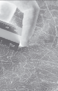
In Figure 3.8 the contours are closer together. Using the same scale,
the zero tick mark is positioned over the 400 contour, and the 300 con-
tour is located at the 1100-foot mark. The slope percent is calculated as
follows:
S = V / H
S = 100/1100
S= 0.1 or 10 %