Agriculture Reference
In-Depth Information
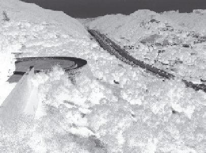
The photograph with graphic annota-
tions in Figure 11.17 follows the same con-
tour signature of the swale. This contour
signature characterizes a valley or ravine
in a mountainous landscape. Note how the
contours move up the highway, creating an
inverted V shape. This inverted V shape is
a contour signature for a valley, swale, or
ravine landform. Notice further how the
contours bow or follow around the hills
on either side of the highway valley. This
rounded or bowed-out form of successive
contours is the signature of a hill, mound,
or embankment.
The pattern of trees—in some instances
planted by the farmers—and the country
road found in Figure 11.18 follow the terrain
much as contours would do. Notice how
the lines of trees roughly approximate how
contours would follow the terrain in the
landscape and bow out to reinforce the hill
signature, as opposed to how they turn ups-
lope to form a valley following the contours
in Figure 11.17. While the same landscape
without the pattern of trees would still be
seen as a hilly landscape, the tree pattern
accentuates the sculptural quality of the hilly
terrain. If you were to look at a topographic
map of this same landscape, with the con-
tours, you should be able to distinguish and
visualize the valley and the hill-forming
patterns.
33.2
29 .5
32
33
31
2%
32
31
30
Figure 11.16
The culvert allows water in the swale
to pass under an entrance road
240
220
240
220
200
200
180
160
!
140
Figure 11.17
The path of the I 405 Freeway in Los
Angeles follows the base of a mountain and valley
landscape, in this case a mountain pass
Figure 11.18
Rural farmland in Northern Spain