Agriculture Reference
In-Depth Information
Figure 8.5-A illustrates what contours would look like on a slope where
the contours are parallel to one another. In the center of Figure 8.5-B,
you can see what contours that fall on a similar planar slope look like
in plan. A simple level or flat area is shown in Figure 8.6-A. The cen-
tral level area is bordered by a sloping embankment that appears fairly
steep, as shown by the closely spaced horizontal distance separating the
contour lines in Figure 8.6-B.
Figures 8.6-a and 8.6-B
Level landform signature
WaterShed Landform SiGnature
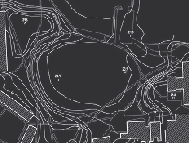
Watersheds come in all shapes and sizes. A watershed can be as small
as a couple of hundred square feet or many millions of square miles, like
the Mississippi River watershed. Figure 8.7 is an aerial view of a South-
ern California mountain range with three sub-watersheds outlined. A
designer may create a watershed in developing a grading solution in
situations where surface waters are collected within a semi-enclosed
landform to then flow downhill in the direction of a pond or stream sim-
ilar in concept to a watershed. An example of how a designer applied the
watershed concept for a paved landscape is shown in Figure 8.8.