Environmental Engineering Reference
In-Depth Information
urban rounds (75 %), flow distribution cannot be established using a gravity model
as they are oriented and organized according to a fluctuating logic unknown to the
modeller (Routhier and Toilier
2010
). Thus the same round can be carried out in
one direction or the other, or by serving points in various orders, these instanta-
neous changes being due to traffic conditions, retailers' opening hours and also
other constraints external to the round itself.
This volatility in round itineraries did not lead to a round model, but simply to
flows between points on the round. Consequently, a probabilistic distribution
model was chosen (Toilier et al.
2005
). Thus, for any delivery or pickup operation
estimated using the simulated generation module and characterized by a set of
criteria (area, vehicle used, type of organization, size of the round, management
mode, etc.) we select a distance function from a 25 group-classification. This
function indicates the average distance to the next point on the round. The
neighbourhood of each zone is defined automatically. To estimate the distance
between two zones z
i
and z
j
, a macro-network is built to link the centroids of
contiguous zones. Then, the average time taken by transport T
ij
to travel from z
i
to
z
j
is obtained with the following relation:
T
ij
¼
RD
i1
=
s
i1
þ
RD
12
=
s
12
þ þ
RD
nj
=
s
nj
The choice of best path on the macro-network can be obtained on two ways.
The first is to use an average distance database that relates each pair of zones. The
second is that of using a shortest path algorithm (Dijkstra
1959
) to estimate a
suitable path to link two zones by a freight vehicle, in travel time (and not physical
distance ''as the crow flies''). For each distance function, a confidence threshold is
defined to determine which zones are susceptible to exchange freight with the zone
considered, given an operation type, a vehicle type and a management mode. For
each zone z
i
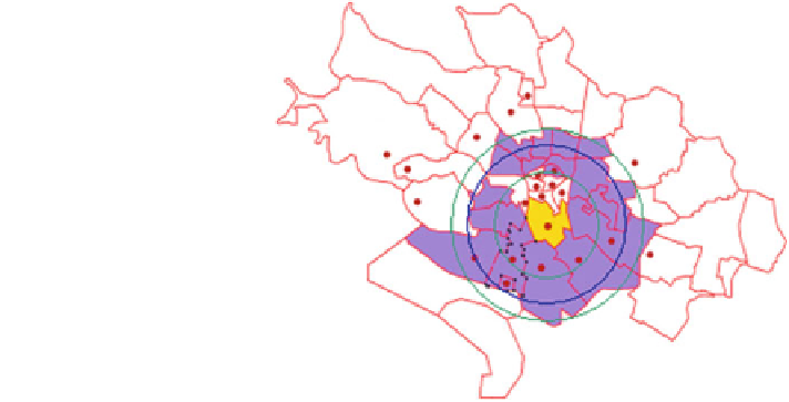
a set of zones is defined using a ring-based procedure, as illustrated
below (Fig.
6
):
Fig. 6 Potential reception
zones (in dark) eligible to
receive trips generated by the
emission zone (lighter), for
the French city of Dijon
(adapted from Toilier et al.
2005
)
Search WWH ::

Custom Search